The Loess Hills in Missouri

The term Mountains in Miniature is the most expressive one to describe these bluffs. They have all the irregularity in shape, and in valleys that mountains have, they have no rocks and rarely timber. – Thaddeus Culbertson, missionary, 1852


One of the things I enjoy most about the natural history of Missouri is its diversity. Lying in the middle of the North American continent, it is here where the eastern deciduous forest yields to the western grasslands. Coinciding with this transition between two great biomes is a complex intersection of landforms – the northern plains, recently scoured by glaciers; the southeastern lowlands, where the great Mississippi River embayment reaches its northern extent; the Ozark Highlands, whose craggy old rocks comprise the only major landform elevation between the Appalachian and Rocky Mountains; and the eastern realm of the vast Great Plains. This nexus of east and west, of north and south, of lowlands and highlands, has given rise to a rich diversity of natural communities – 85 in all according to Paul Nelson (2005, Terrestrial Natural Communities of Missouri). Despite the overwhelming changes wrought upon Missouri’s landscape during the past 200 years, passable examples of most of these communities still exist in many parts of the state and provide a glimpse of Missouri’s rich natural heritage.

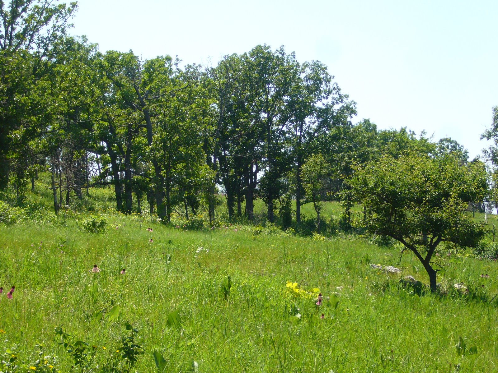
Last month I talked about the critically imperiled sand prairie community in extreme southeast Missouri. This month, we travel 500 miles to the distant northwestern corner of the state to visit another critically imperiled community – the dry loess prairie. These communities are confined to thin slivers of bluff top along the Missouri River in Atchison and Holt Counties. The bluffs on which they lie are themselves part of a unique landform called the Loess Hills. Like the sand prairies of the southeastern lowlands, this angular landscape owes its birth to the glacial advances of the Pleistocene epoch (2.5 million to 10,000 years ago), when streams of meltwater – swollen and heavily laden with finely ground sediments (i.e., glacial “flour”) – filled river valleys throughout the Midwest during Pleistocene summers. Brutal cold during winter reduced these flows to a trickle, allowing the prevailing westerly winds to pick up the sediments, left high and dry, and drop them on leeward upland surfaces across Iowa and northern Missouri. The thickest deposits occurred along the abrupt eastern border of the Missouri River valley – at least 60 feet deep, and in places up to 200 feet. Loess (pronounced “luss”) is a homogeneous, fine-grained, quartz silt – undisturbed it is highly cohesive and able to stand in near vertical bluffs. It is also extremely prone to erosion, and as a result for 10,000 years now the forces of water have reshaped the Loess Hills into the landform we see today. Loess itself is not rare – thick deposits can be found in many parts of the world and over thousands of square miles across the Midwest. It is here, however, along the western edge of Iowa and northern Missouri – and nowhere else in North America – where loess deposits are deep enough and extensive enough to obliterate any influence by the underlying bedrock and dictate the form of the landscape.

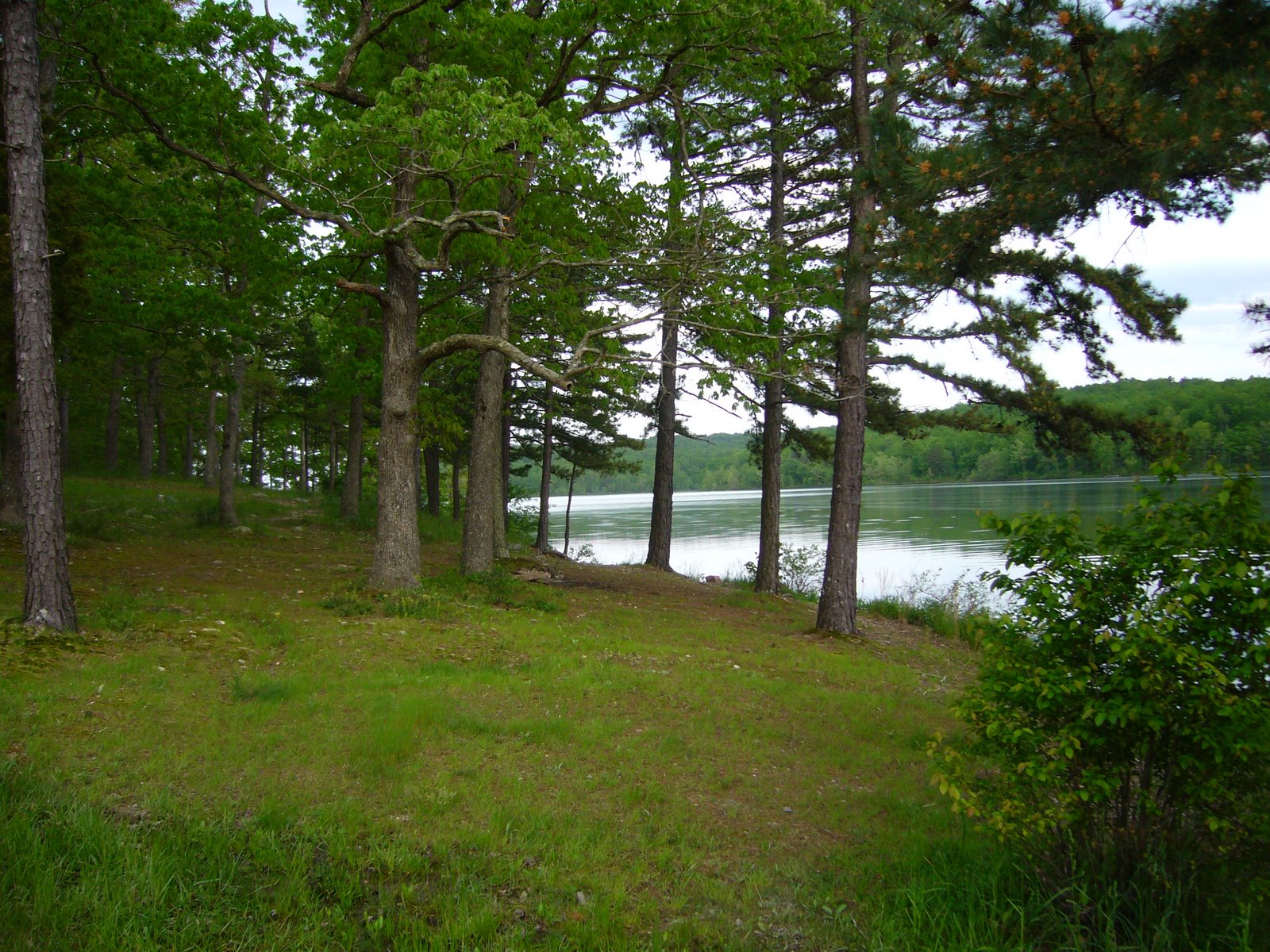
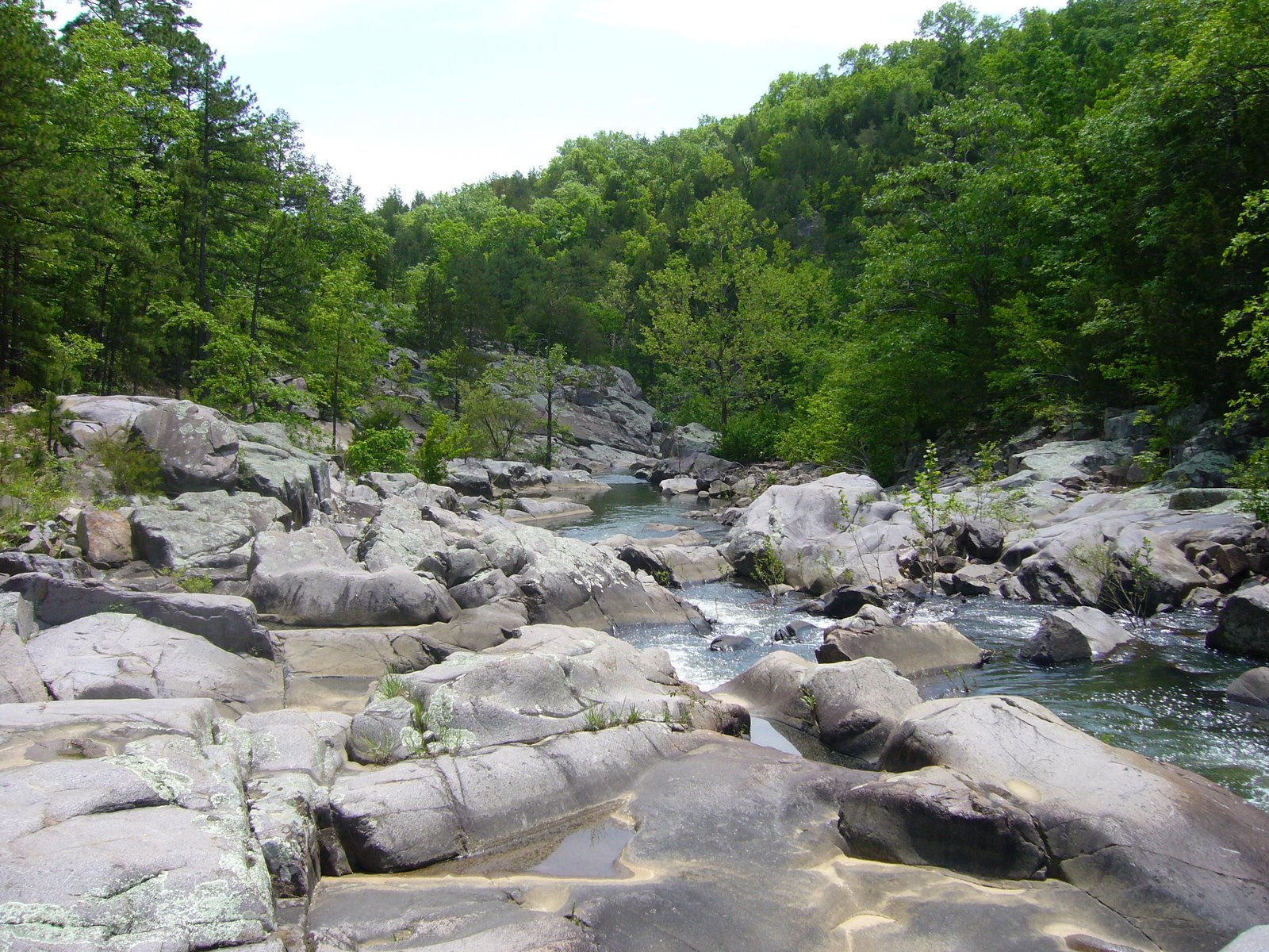
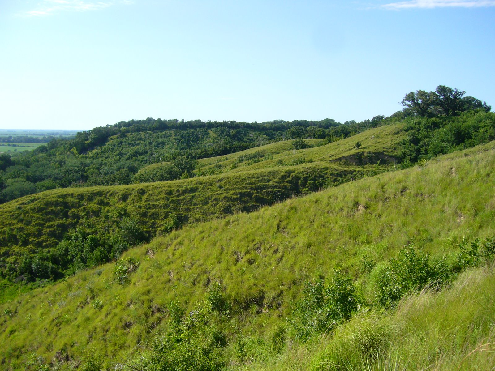
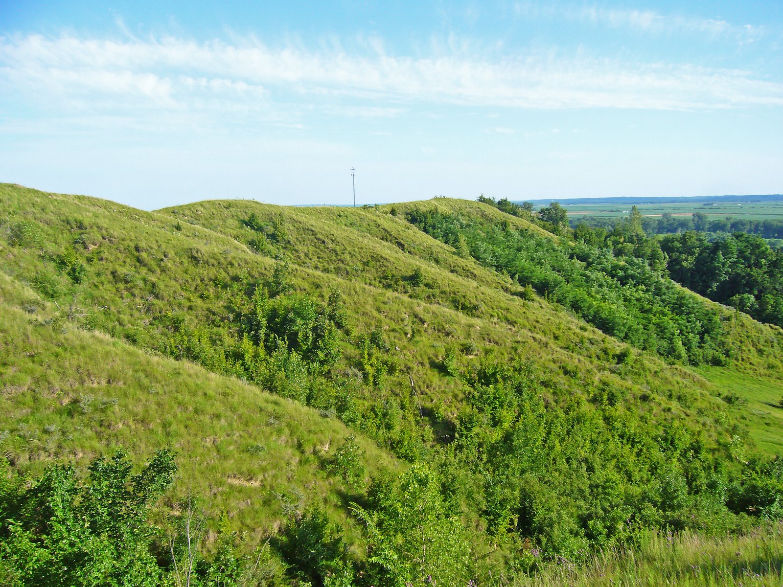
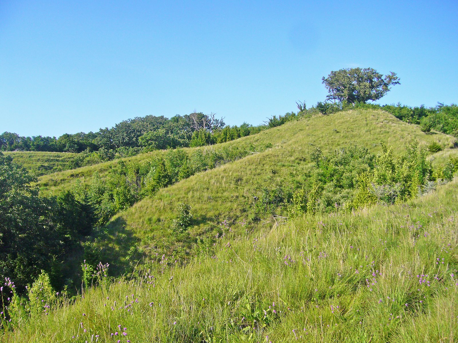
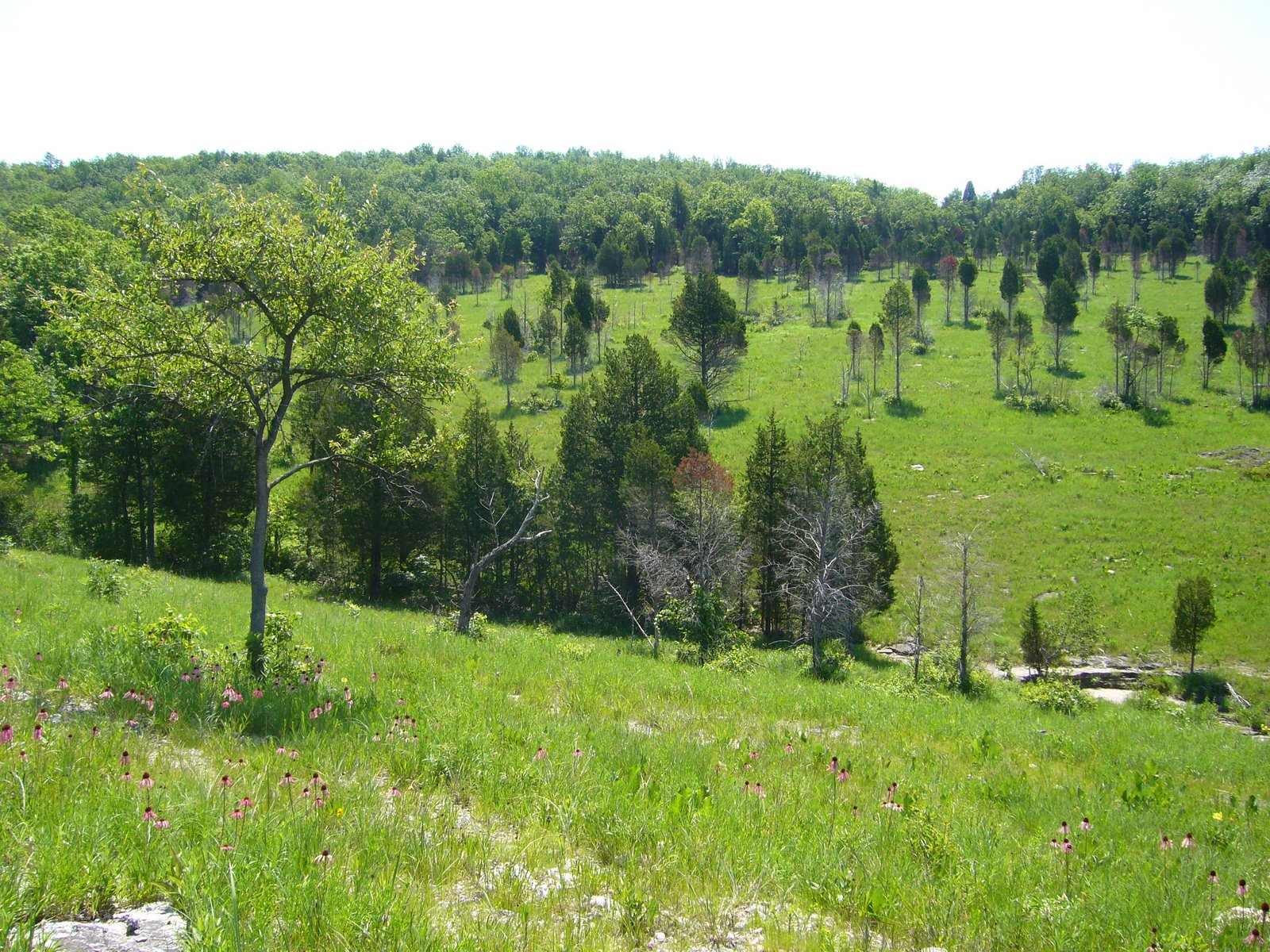
It is this form that makes the Loess Hills so unique. The depth of the soil, its cohesiveness, its natural tendency to slump on steep slopes and sheer in vertical planes, and the action of water over the past several millenia have created a landscape of narrow undulating ridges flanked by steep slopes and numerous side spurs, intricate drainages with sharply cut gullies, and long, narrow terraces called “catsteps” cutting across the steep upper hillsides. It’s a sharp, angular, corrugated landscape, stretching 200 miles north and south in a narrow band of varying width from north of Souix City, Iowa, to its southern terminus in northwestern Missouri. Its western boundary is sharply delimited by the Missouri River valley, where lateral erosion (now halted by channelization of the river) and vertical sheering have created precipitous bluff faces. The eastern boundary is harder to delimit and is dependent upon the thickness of the loess. Deposits that fall below 60 feet in depth are unable to mask and reshape the rolling terrain of the eroded glacial till lying beneath. In general, this happens at distances of only 3 to 10 miles from the western edge of the landform.

Its southern terminus in Missouri, however, is the most arbitrary boundary. Discontinuous patches of deep loess terrain do occur as far south as Kansas City, but the dry hilltop prairies, common in the north, are gradually replaced by woodland in the south and disappear completely just north of St. Joseph. It is this interdigitation of two great biomes – the great deciduous forest to the east, and the expansive grasslands stretching far to the west – that give the Loess Hills such a fascinating natural history. This is due as much to the physical character of the Loess Hills themselves as to their ecotonal position at the center of the continent. Rapid drainage of rainwater off the steep slopes combines with direct sun and prevailing southwesterly summer winds to create very dry conditions on hilltops and south and west facing slopes, especially on the steeper slopes along the landform’s western edge. Such xeric conditions favor the growth of more drought-tolerant species derived from the western grasslands. North and east facing slopes and valley floors, protected from direct sun and drying winds, are able to retain more moisture, favoring the growth of woody plant species more common in the eastern forests. Seasonal moisture also shows a north-south gradient, with southern latitudes receiving higher annual rainfall totals that also favors the growth of woody plants, while the lower rainfall totals further north result in larger, more expansive grassland habitats. The steep slopes and rapid drainage create much more xeric conditions than those found further south in the flat to rolling terrain of the unglaciated Osage Plain, resulting in a more drought-tolerant mixed-grass prairie rather than the tallgrass prairie of western and southwestern Missouri. The distribution patterns of prairie versus woodland are dynamic and ever-changing, influenced by both natural and anthropogenic processes. Climatic conditions over much of the Loess Hills are capable of supporting either community type, both of which repeatedly expand and shrink as the balance tips in favor of one versus the other. In the past, the major influence was shifting periods of greater or lesser rainfall. During drier periods, grasslands expanded and woodlands shrank, finding refuge in only the moistest streamside habitats. Wetter periods allowed woody plants to migrate out of the valleys and up the slopes, especially those facing north and east. One particular very dry “hypsithermal” began about 9,000 years ago and lasted for several thousand years. Tallgrass prairies expanded as far east as present day Ohio, and todays tallgrass praires in the eastern Great Plains were invaded by even more drought-tolerant species from the shortgrass prairies further west. Eventually the hypsithermal abated, moisture levels increased, and the grasslands retreated in the face of the advanding forest. 
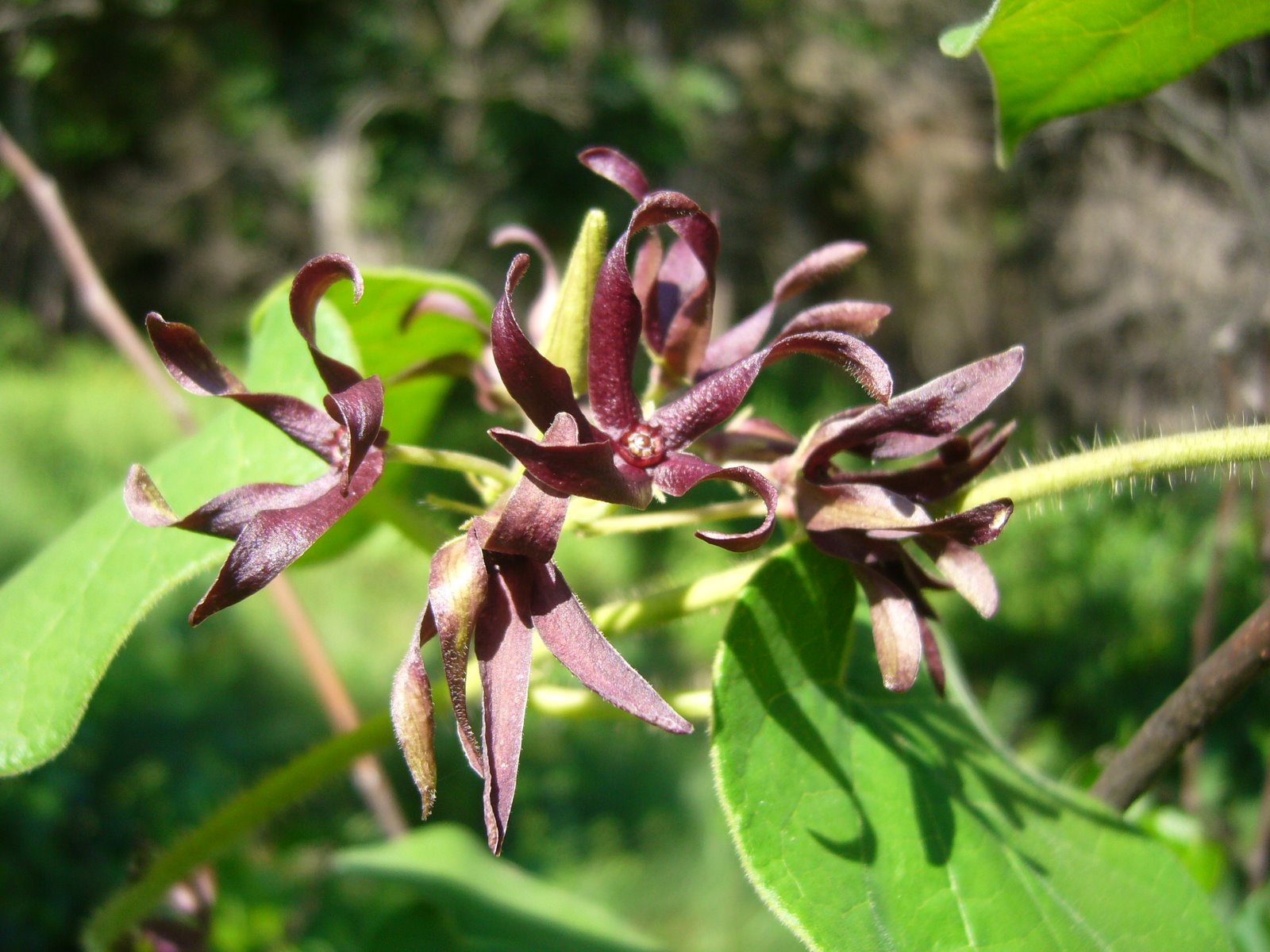
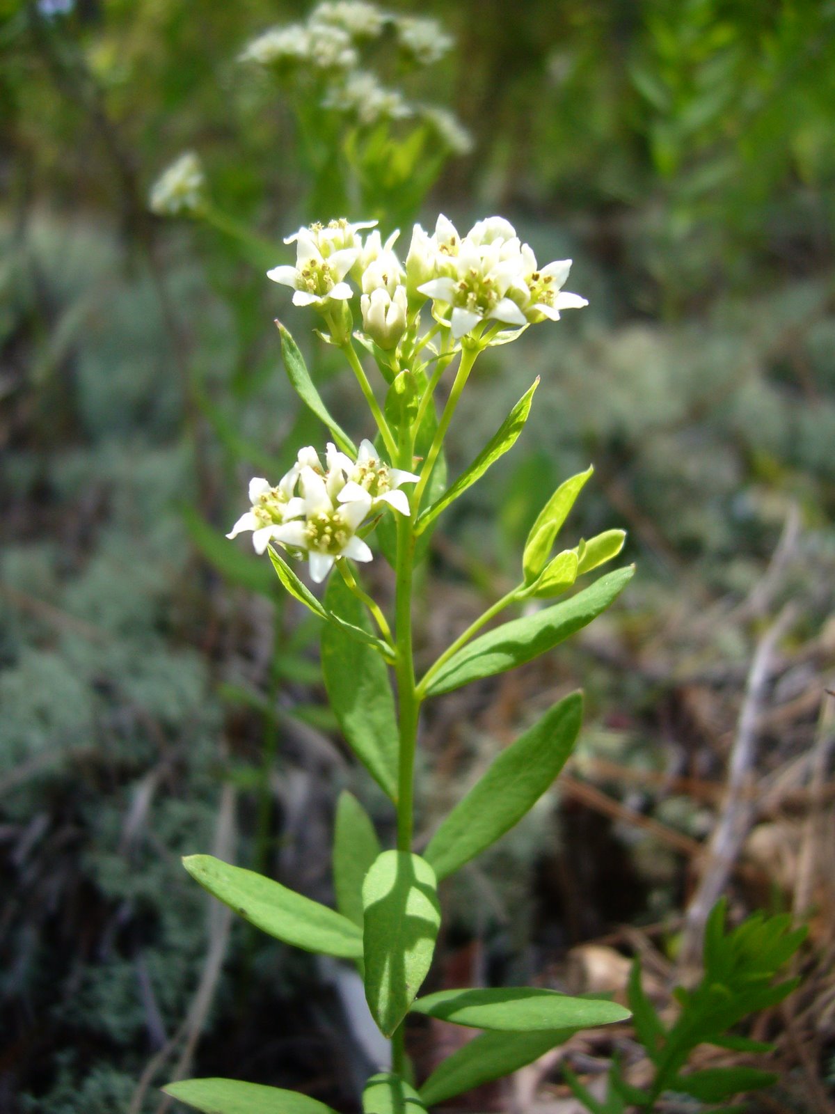
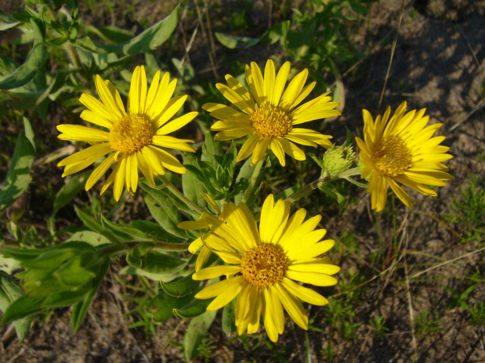
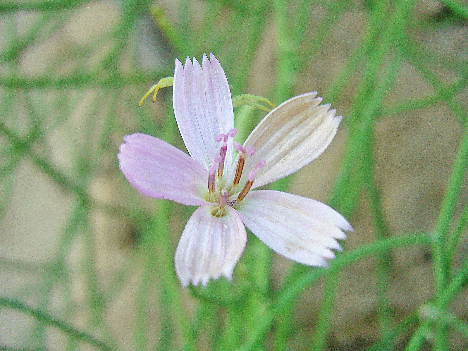
Not all of the drought-tolerant species were driven back, however, and scattered populations of these “hypsithermal relicts” still remain on locally dry sites far to the east of their normal range of distribution. Conspicuous examples of such in Missouri’s Loess Hills are soapweed yucca (Yucca glauca var. glauca) and the leafless-appearing skeletonweed (Lygodesmia juncea) (plant above, flower right). Both of these plants are normally found further west in the mixed grass prairies of the western Great Plains but are considered endangered in Missouri due to the great rarity of the dry loess prairies on which their survival depends. (Incidentally, note the crab spider legs extending from behind the petals of the skeletonweed flower). In total, more than a dozen plant species occurring in Missouri’s dry loess prairies are listed as species of conservation concern, along with one reptile (Great Plains skink) and one mammal (Plains pocket mouse).

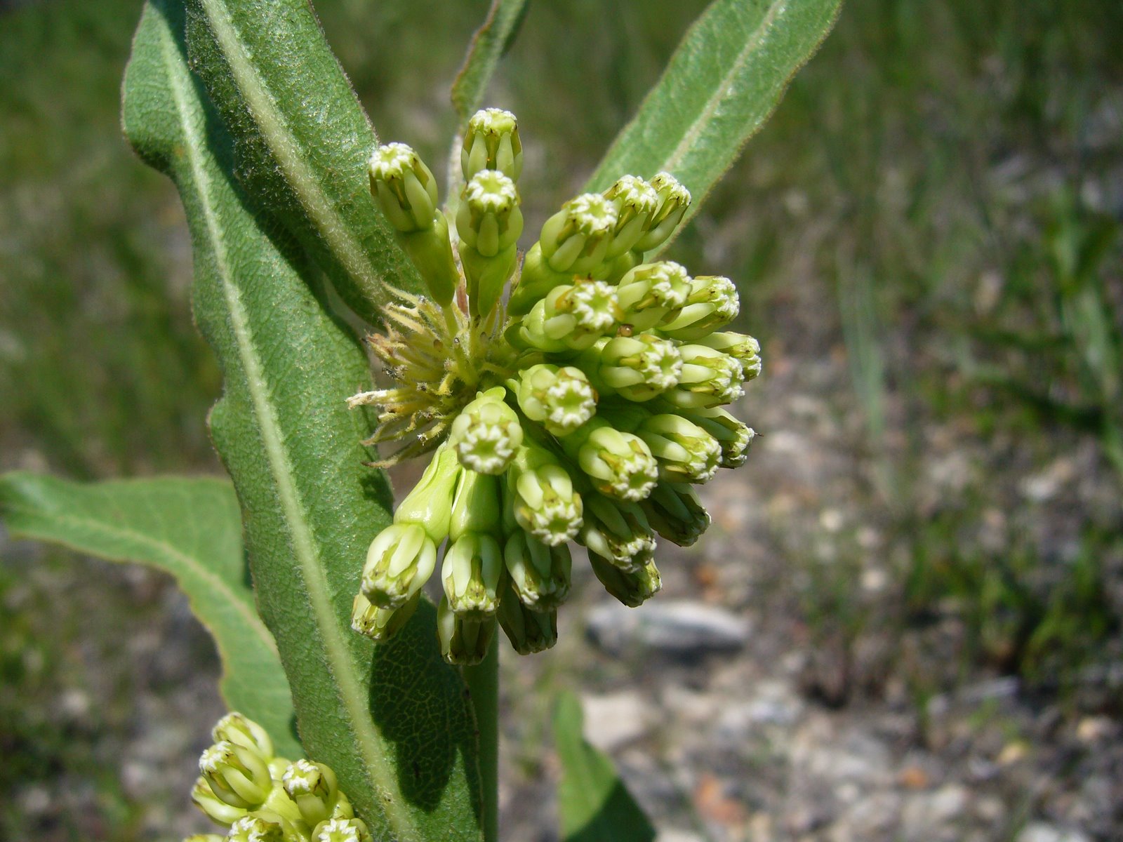
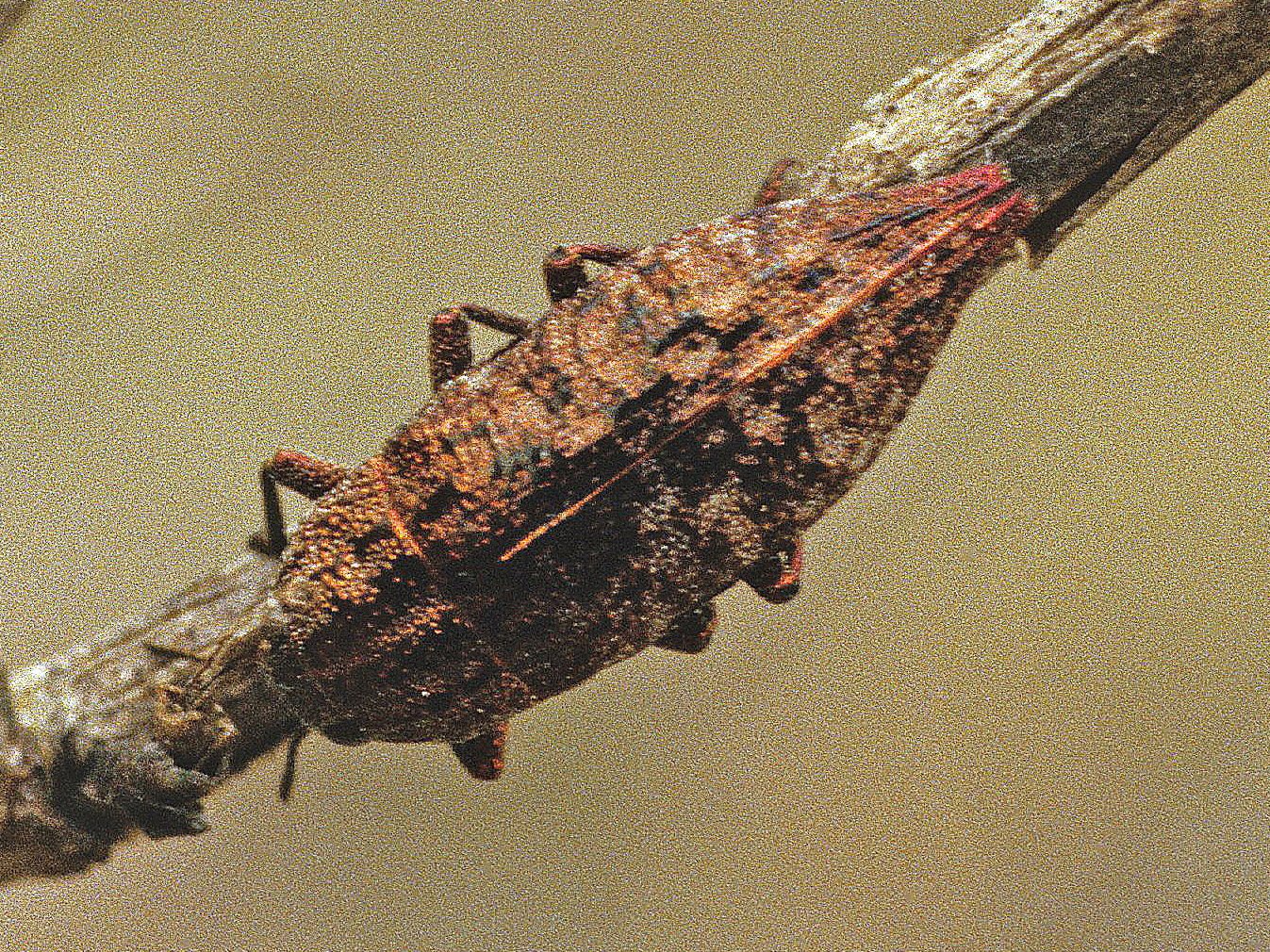
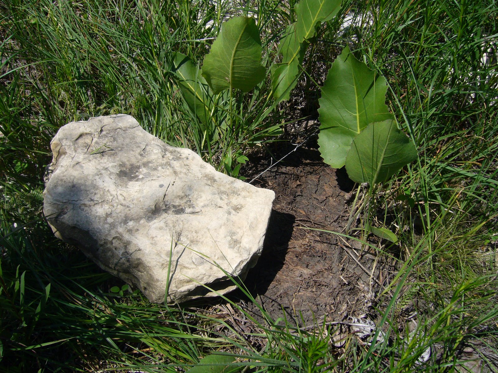
As is typical, the insect fauna of the Loess Hills has been far less studied than its plants, but many of the species that have been documented in its prairies also show affinity to the Great Plains fauna. 
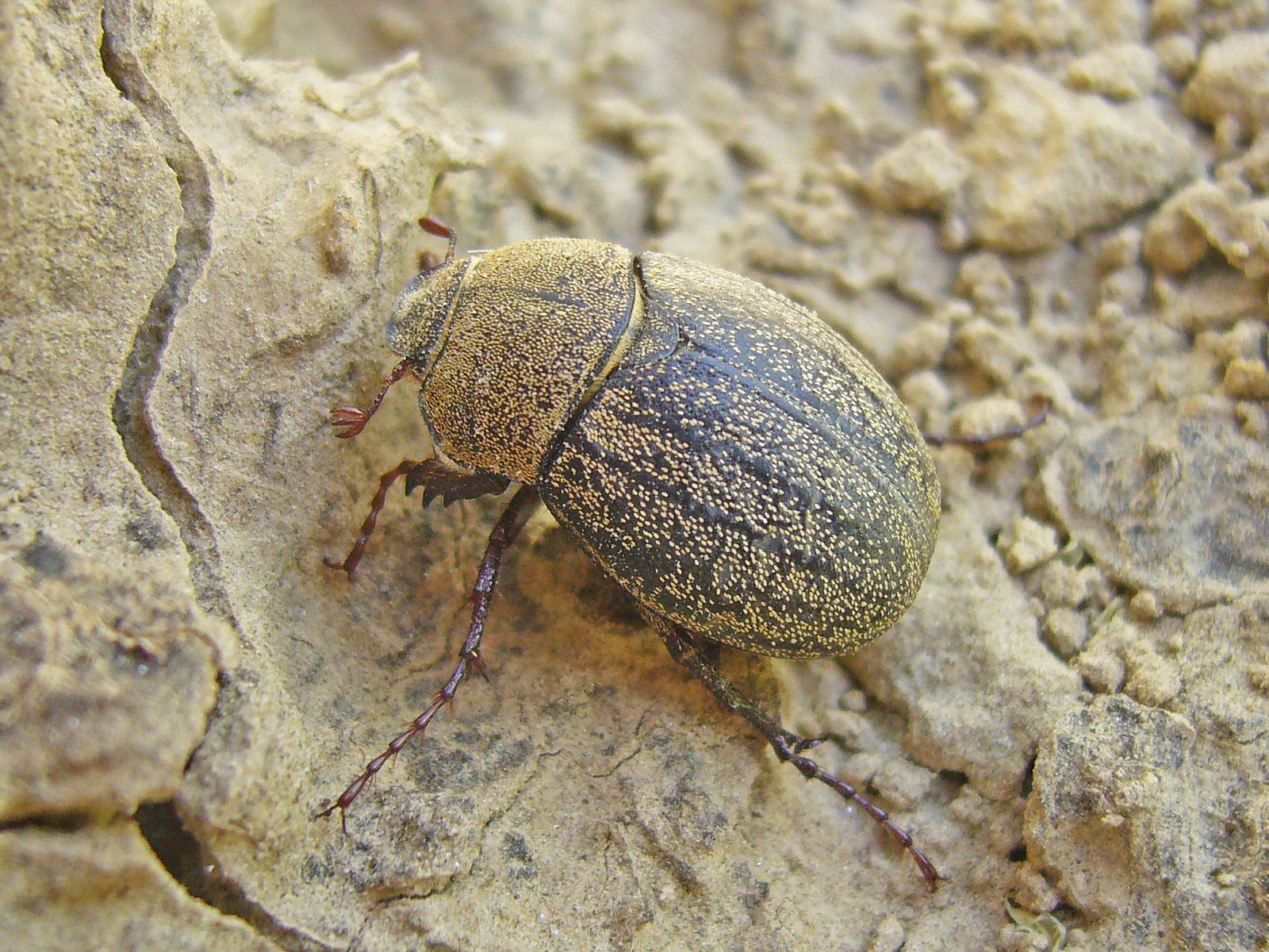
Both soapweed and skeletonweed have insect associates that rely exclusively on these hosts for reproduction, and as a result they are also highly restricted in Missouri. Evidence of one of these – a tiny cynipid wasp (Anistrophus pisum) that forms small spherical galls on the stems of skeletonweed – can be seen in the photo above. However, my purpose for visiting the Loess Hills this summer was to look for the rare and possibly endangered tiger beetle, Cicindela celeripes (see this post). Cicindela celeripes has not yet been recorded from Missouri but is known to occur in the Loess Hills of southwestern Iowa, and while I have not succeeded in finding it (yet!) I did observe several adults of this unusual May beetle species, Phyllophaga lanceolata. This May beetle occurs throughout the Great Plains in shortgrass prairie communities. Larvae feed in the soil on roots of grasses and other plants, while adults feed above ground on flowers and foliage. The heavy-bodied adults are unusual in the genus due to their conspicuous covering of scales (most species of Phyllophaga are glabrous or with sparsely scattered and indistinct setae) and by being active during the day. They are also relatively poorer fliers and are thus usually observed moving about on foot – as seen with this individual who was found on bare soil below a vertical cut. This snakeweed grasshopper (Hesperotettix viridis, ID by Eric R. Eaton) is another species more typically seen in the western United States, although populations have been found from across the continent. Preferred host plants include a variety of asteraceous shrubs, but as suggested by the common name snakeweeds (Xanthocephalum spp.) are highly preferred and account for its greater abundance in the west. Populations in northern and eastern portions of its range, 
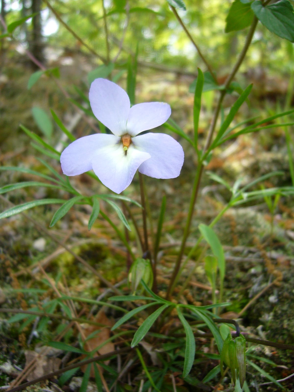
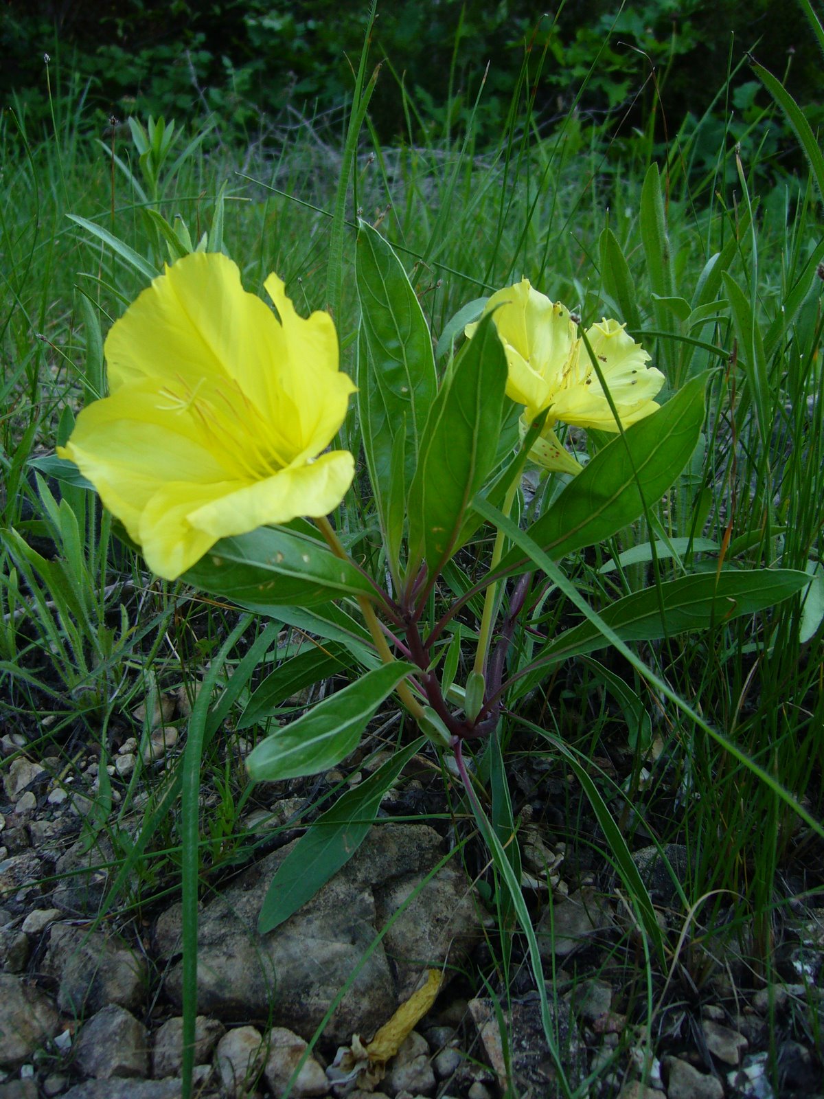
which would include northern Missouri, are considered subspecies pratensis, while the more southern and western populations are considered the nominotypical subspecies. Interestingly (and unlike many grasshoppers), this species is considered beneficial by ranchers, since the plants on which it prefers to feed are either poisonous to livestock or offer little nutritional value while competing with more desirable forage plants for soil moisture. While exploring the upper slopes, I encountered sporadic plants of two of Missouri’s more interesting species of milkweed – whorled milkweed (Asclepias verticillata) and green milkweed (Asclepias viridiflora), raising my hopes that I might encounter one of the many Great Plains species of milkweed beetles (genus Tetraopes). However, the only species I observed was the common milkweed beetle, Tetraopes tetrophthalmus, which occurs broadly across eastern North America on the equally broadly distributed common milkweed (Asclepias syriaca).

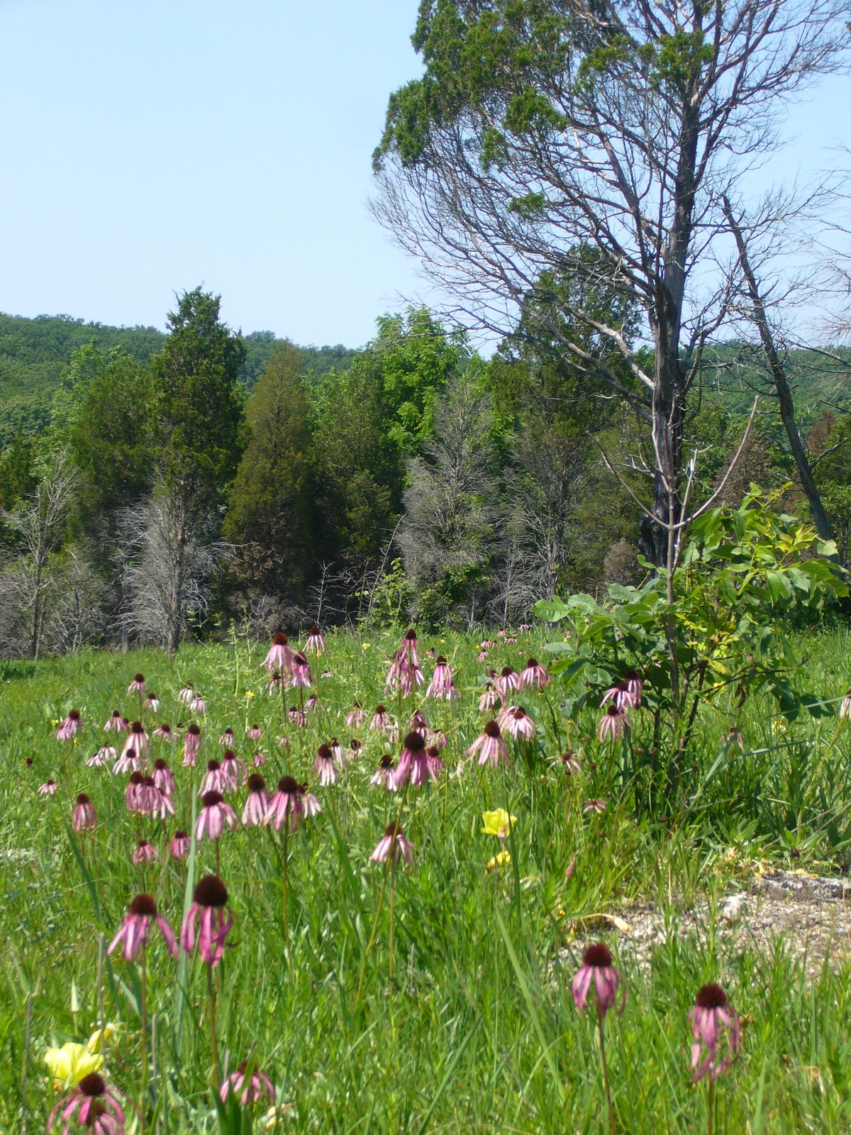
It is a familiar refrain, but Missouri’s dry loess hill prairie communities are critically endangered. Historically, these communities were probably never as well developed as those further north, and only a few small remnants remain today due to significant woody encroachment following decades of fire suppression. Much of this encroachment has occurred in the past 50 years – Heinman (Woody Plant Invasion of the Loess Hill Bluff Prairies. M. A. Thesis, University of Nebraska at Omaha, 1982) used aerial photographs to show a 66 percent encroachment of shrubs and trees into the loess hill mixed-grass prairies between 1940 and 1981. Additional threats include overgrazing, erosion, invasion by exotic plant species and homesite development. Fewer than 50 acres of native dry loess hill prairie remain in Missouri – only half of which are now in conservation ownership. The majority of these can be found at Star School Hill Praire and Brickyard Hill Conservation Areas in Atchison County and at McCormack Conservation Area just to the south in Holt County. Controlled burning and selective cutting are being used at these sites to control woody plant invasions, but even these management techniques present challenges. Spring burns have been shown to promote the growth of big bluestem (Andropogon gerardii), which could allow it to encroach drier areas where mid-grasses such as little bluestem (Schizachyrium scoparium) and sideoats grama (Bouteloua curtipendula) typically dominate (Rushin 2005). Increases in tall grasses could shade out and eliminate some of the rarer low-growing forbs such as downy painted cup (Castilleja sessiliflora), locoweed (Oxytropis lambertii) and low milkvetch (Astragalus lotiflorus). Fall or winter burns may be more beneficial to forbs because the plants are allowed to complete flowering and seed set, but the steep slopes on which these communities occur make erosion a potential concern. Clearly, all factors must be considered when designing management plans for this rare and significant slice of Missouri’s natural heritage.


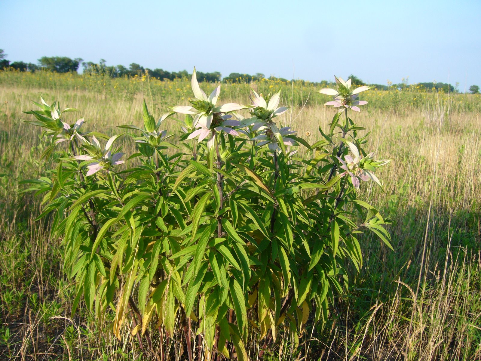
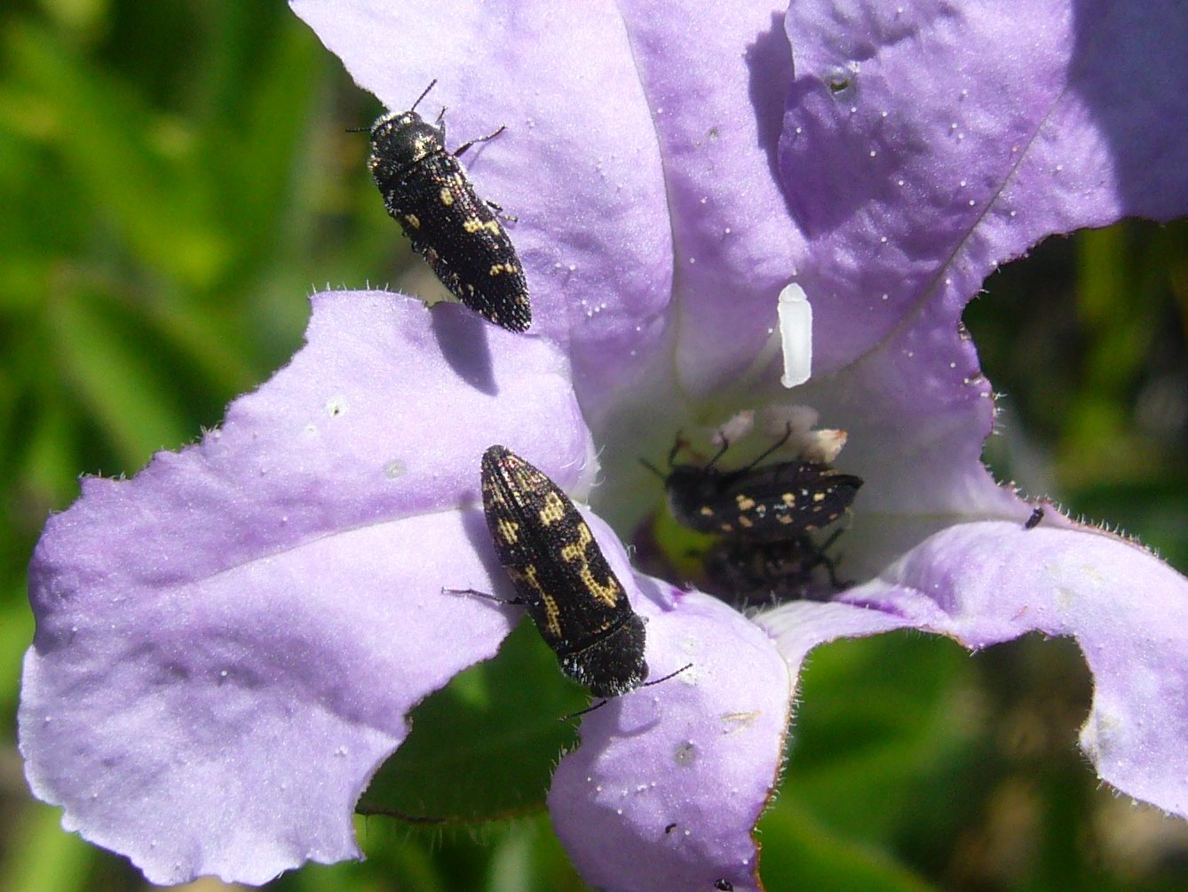
In addition to the links and references provided above, I highly recommend Fragile Giants: A Natural History of the Loess Hills, by Cornelia F. Mutel (1989). All of the above photographs were taken at Star School Hill Prairie Conservation Area on July 12, 2008. Additional photographs of Loess Hill habitats in extreme southwestern Iowa appeared in my earlier post, The hunt for Cicindela celeripes. The plants shown in photographs 5-7 are purple praire clover (Dalea purpurea), white prairie clover (D. candida), and lead plant (Amorpha canescens), respectively. Lastly, I would like to apologize for the length of this post – a consequence of my inability to temper my utter fascination with the natural world and desire to understand the depths its connectedness.

Sand Prairie Conservation Area

I have a love-hate affair with Missouri’s Southeast Lowlands (formally known as the Mississippi River Alluvial Basin, but simply called the “bootheel” by most folk in reference to the shape of its boundaries). Of the four main physiogeographic regions in the state, it is by far the most altered. Yes, the Ozark Highlands have been degraded by timber mismanagement, overgrazing, and fire suppression, yet many of its landscapes nevertheless remain relatively intact – just a few burn and chainsaw sessions away from resembling their presettlement condition. The northern Central Dissected Till Plains and western Osage Plains are more disturbed, their prairie landscapes having been largely converted to fields of corn, soybean, and wheat. Still, riparian corridors and prairie habitats ranging from narrow roadsides to sizeable relicts combine to provide at least a glimmer of the regions’ former floral and faunal diversity. The alterations these regions have experienced are significiant, yet they pale in comparison to the near-total, fence-row-to-fence-row conversion that has befallen the Southeast Lowlands. Its rich, deep soils of glacial loess, alluvial silt, and sandy loam originally supported vast cypress-tupelo swamps and wet bottomland forests – massively treed and dripping with biotic diversity. Exposed by relentless logging and an extensive system of drainage ditches and diversion canals, those same soils now support monotonous expanses of soybean, wheat, rice, and cotton. Giant plumes of dark smoke dot the unendingly flat landscape in late spring, as farmers burn wheat stubble in preparation for a double-crop of soybean (the need for which could be obviated by adopting more environmentally benign no-till drillers). Only a tiny fraction of the original swamp acres remain intact, preserved more by default due to their defiant undrainability than by human foresight, and wet bottomland forests now exist only as thin slivers hemmed in by levees along the Mississippi River to the east and the St. Francois River to the west. Solace is hard to find in these remaining tracts – hordes of mosquitoes and deer flies, desperate for blood to nourish their brood, descend upon anyone who dares to enter their realm, while impoverished locals leave behind waste of all manner in their daily quest for fish. The cultural history of the region parallels its natural history – nowhere in the state is the gap between wealth and poverty more evident, a testimony to its checkered history of race and labor relations.

Yet, despite its shortcomings, I am continually drawn to this region for my explorations. Driving down the southeastern escarpment of the Ozark Highlands into the Lowlands is like entering another world – a world of grits, fried catfish, and sweet tea, a world where it is odd not to wave to oncoming vehicles on gravel back roads, a world where character is judged by the subtleties of handshake, eye contact, and small talk. Again, its natural history follows suit, with many insects occurring here and nowhere else in Missouri – a distinctly Southern essence in an otherwise decidedly northern state. My recent discussion of Cicindela cursitans in the wet bottomland forests along the Mississippi River is just one example of the unique gems I have encountered in this region. Others include the rare and beautiful hibiscus jewel beetle (Agrilus concinnus), a sedge-mining jewel beetle (genus Taphrocerus) that is new to science (and, due to my sloth, still awaiting formal description), the striking Carolina tiger beetle (Tetracha carolina), and numerous other beetle species not previously recorded from the state. The small and scattered nature of the habitat remnants and often oppressive field conditions make insect study challenging here, but the opportunity for discovery makes this region irresistible.

Prior to this season, I had already visited most of the publicly-owned examples of swamp and forest found in the Southeast Lowlands. One natural community, however, that I had not yet seen happened to be one of Missouri’s rarest and most endangered – the sand prairie (I suppose you’ve surmised this by now from the photos). While conducting our recent survey for Cicindela cursitans, I took the opportunity to explore a recently acquired example called Sand Prairie Conservation Area. Geologically, sand prairies lie on our state’s youngest landscape, arising during the relatively recent Pleistocene glacial melts. Tremendous volumes of water from the melting glaciers scoured through loose sands and gravels deposited earlier during the Cretaceous and Tertiary periods by the present day Ohio River (the Mississippi River, much smaller at that time, actually drained northward into Hudson Bay!). After the last of these glacial melts formally ended the “ice age” (only 10,000 years ago), two long sandy ridges were all that remained of the original sand plain. Water drains quickly through the sandy soil of these ridges, which lie some 10 to 20 feet above the surrounding land, creating dry growing conditions favorable for prairie and savanna habitats where only drought-tolerant plants can survive. Dr. Walter Schroeder has conservatively estimated that 60 square miles of sand prairie were present in the Southeast Lowlands at the time of the original land surveys. Because settlement was already occurring at that time, a substantial amount of sand prairie had already likely been converted to agriculture, urban centers, and travel routes to staging areas for access across the swamps. Considering the conversion that might have already taken place, it is possible that as much as 150 to 175 square miles of sand prairie occupied the sand ridges. Sandy areas with higher organic soil content and supporting tallgrasses would have been the first to be converted, since this organic content would have also made them the most suitable for agriculture. Those with lower organic content created drier conditions more suitable for shortgrasses and were the next to be converted. Today, less than 2,000 acres of sand prairie remain – not even 1% of the original amount, and these relicts likely represent the sandiest (and driest) examples of the original sand prairie.

Walking onto the site, I was immediately greeted by an otherworldly expanse of sand dunes, blows, and swales. Ever the entomologist, and with tiger beetles in the fore from hunting C. cursitans, I immediately thought of two dry sand associated species that I have seen in the sand woodlands of nearby Crowley’s Ridge – Cicindela formosa (big sand tiger beetle) and Cicindela scutellaris (festive tiger beetle). These are both so-called “spring-fall” species – i.e., adults are active primarily during spring and fall, so I thought it might be a little late (my first visit was in late June) to see either one. It wasn’t long, however, before I scared up a C. formosa (pictured – but unfortunately facing the setting sun) on one of the dunes. I also encountered one individual of another dry sand associated species, Cicindela lepida (a white “summer” species aptly named ‘ghost tiger beetle’) but was not able to photograph it (I have to say this – I’m a patient man, but photographing tiger beetles is hard. Actually, stalking them until you can get close enough to photograph them is hard. Stalking them until you can get even closer to photograph them with a ‘point and shoot’ – hoping and praying they settle into a pose with the sun on their back because you can’t use the blindingly dinky little built-in flash – just about breaks every last fiber of patience I have within my soul!). Though the site represents a new county record for both species, this is not unexpected, since we have recorded each at multiple dry sand sites near big rivers throughout the state. The occurrence of C. scutellaris at this site, on the other hand, would be significant, and though I did not find it on these two summer visits, I will certainly return this fall to have another look. Cicindela scutellaris has been recorded from just three widely separated locations in the state. Individuals from the two northern Missouri sites are assignable to the more northerly and laterally maculate subspecies C. scutellaris lecontei, but those from the Crowley’s Ridge population (some 20 miles to the west) show an intergrade of characters between C. s. lecontei and the more southerly all-green and immmaculate subspecies C. scutellaris unicolor. I should mention that I believe the classic definition of subspecies (i.e., allopatric populations in which gene flow has been interrupted by geographic barriers) has been grossly misapplied in Cicindelidae taxonomy, with many “subspecies” actually representing nothing more than distinctive extremes of clinal variation. Nevertheless, I am anxious to see if C. scutellaris does occur at Sand Prairie, and if so does it exhibit even more of the “unicolor” influence than does the Crowley’s Ridge population?

I’ve mentioned previously my weakness as a botanist, a fact I found especially annoying as I explored this new area and found myself unfamiliar with much of the flora that I encountered. I’ve taken photographs and will, over time, attempt to identify them. Still, some plants are unmistakeable, such as this clasping milkweed (Asclepias amplexicaulis, also known as sand milkweed) – unfortunately well past bloom. Asclepias is a favorite plant genus of mine (I’ve made it a personal goal to locate all 16 of Missouri’s native Asclepias), so you can imagine my delight when I encountered numerous robust green milkweed (Asclepias viridiflora) plants in full bloom. As I approached one of these plants, I noticed the unmistakeable form and color of a milkweed beetle (genus Tetraopes). It didn’t have the look of the common milkweed beetle (Tetraopes tetrophthalmus), which is widespread and abundant throughout Missouri on common milkweed (Ascelpias syriaca), and as soon as I looked more closely, I recognized it to be the much less common Tetraopes quinquemaculatus. Additional individuals were found not only on A. viridiflora, but also on A. amplexicaulis. The latter is also a suspected host (the larvae are root borers in living plants) in other parts of the species’ range, but in Missouri I’ve found this species associated only with butterfly weed (Asclepias tuberosus). These observations suggest not only that A. viridiflora may also be utlized as a host, but that three species of milkweed are serving as such in this part of the state – unusual for a genus of beetles in which most species exhibit a preference for a single milkweed species in any given area. More questions to answer!

Amazingly, there were no publicly owned representatives of this community type in Missouri until just recently, when the Missouri Conservation Department acquired Sand Prairie CA through the efforts of the Southeastern Sand Ridge Conservation Opportunity Area, a consortium of private and public agencies dedicated to the conservation and restoration of sand prairies in the Mississippi River Alluvial Basin. Restoration efforts are now underway to promote species that historically occupied native sand prairies on the Sikeston Sand Ridge. Fire is one such management tool, although there seems to be some debate about the role of fire in the history of this natural community. Some have argued that the Southeast Lowland sand prairies are an anthropogenic landscape, created by Native Americans who regularly cleared and burned the land after arriving in the Mississippi River Alluvial Plain. Had it not been for such intervention, the sand ridges communities would have remained sand woodlands and forests, dominated by hickories and oaks. Several lines of evidence – convincingly summarized by Allison Vaughn in “The Origin of Sand Prairies” (June 2008 issue of Perennis, Newsletter of the S.E. Missouri Native Plant Society) – suggest a more natural origin. These include the presence of rare sand prairie endemics that do not occur in the sand woodlands of nearby Crowley’s Ridge and the fact that the remaining sand prairie relicts have not succeeded back to sand woodland despite 150 years of post-settlement fire suppression. Perhaps the truth lies somewhere in between, with the driest prairies remaining open regardless of fire, while those with somewhat higher organic content in their soils supported shifting mosaics of prairie, savanna, and woodland as fire events (whether natural or anthropogenic) flashed across different areas. Regardless of their history, the sand prairies of the Southeast Lowlands are truly unique communities that deserve protection. Restoration efforts are well underway at Sand Prairie CA, as evidenced by the charred grass clump next to eastern prickly pear (Opuntia humifusa) in the above photo. There is still more work to do, however, as illustrated by this attractively scenic, yet unfortunately exotic Persian silktree (Albizia julibrissin) still remaining on the parcel – emblematic of Man’s pervasive alterations in even the most unique of landscapes.

For further reading on the sand prairies of the Southeast Lowlands, I recommend the excellent article, “A Prairie in the Swamp”, by A. J. Hendershott and this blog entry by the ever-eloquent author of Ozark Highlands of Missouri. In the meantime, so as not to disappoint the botanists who may stumble upon this silly post, I leave you with a few photographs of some of the wildflowers I saw during my visits. I consider the plant in the first photograph to be camphorweed (Heterotheca sp., either camporum or subaxillaris), frequntly associated with sandy soils in southern Missouri (especially the Southeast Lowlands). My colleague James informs me the second plant is plains puccoon (Lithospermum caroliniense), another sandy soil associate found primarily in the Lowlands and distinguished from the much more common L. canescens by its robustness and rougher pubescence. Both of these species were common near the perimeter of the barren sand areas and nearby. The third plant appears to be spotted beebalm (Monarda punctata) (my thanks to michael for the ID). It was confined, as far as I could tell, to a small area in a swale (moister?) away from the barren sand. This plant, a clump-forming perennial that prefers prairies and open sandy soils, is apparently not common in Missouri, having been found primarily in a few eastern counties adjacent to the Mississippi River.

Glades of Jefferson County

We stood a moment to contemplate the sublime and beautiful scene before us, which was such an assembly of rocks and water—of hill and valley—of verdant woods and naked peaks—of native fertility and barren magnificence… – Henry Rowe Schoolcraft, 1818-1819

In the Ozark Border south of St. Louis, a series of natural openings punctuate the dry, rocky forests of Jefferson County. Commonly called “glades” or “cedar glades,” these islands of prairie in a sea of forest are home to plants and animals more commonly associated with the Great Plains region further to the west. Extending in a narrow arc from central Jefferson County east and south into northern Ste. Genevieve County, these glades occur most commonly on south and southwest-facing slopes below forested ridges and are characterized by thin soils and exposed dolomite bedrock of Ordovician age. Glades are, in fact, a common natural feature throughout much of the Ozark Highlands, an extraordinary plateau where the great eastern deciduous forest begins to yield to the western grasslands. A much more extensive system of dolomite glades occurs in the White River Hills of southwest Missouri, where they often extend up steep slopes and over the tops of knobs to form what Schoolcraft called “naked peaks” and are now called “balds” (and spawning the “Baldknobbers” of Branson fame). Additional glade complexes occur throughout the Ozark Highlands on different rock substrates – igneous glades abound in the St. Francois Mountains, sandstone glades dot the Lamotte landscape in Ste. Genevieve County and the northern and western Ozarks, limestone glades can be found in the northern Ozarks near Danville and Lake of the Ozarks, and chert glades occur in extreme southwest Missouri. These different glade systems share a common feature – shallow soils where tree establishment is limited due to summer moisture stress. They differ vegetationally, however, due to differences in hydrology and soil chemistry as a result of their different substrates. Floristically, dolomite glades exhibit a high degree of diversity relative to other glade types.

The term “glade” is derived from the Old English “glad,” meaning a shining place – perhaps the early settlers found their open landscapes a welcome respite after emerging from the confining vastness of the eastern deciduous forest. Whatever the meaning, the glades of Jefferson County hold a special place in my heart, for I “grew up,” entomologically speaking, in those glades. As a young entomologist, fresh out of school, I spent many a day scrambling through the glades and surrounding woodlands. It was here where my interest in beetles, especially woodboring beetles, was born and later grew into a passion. For eight years I visited these glades often – attracted by the extraordinary diversity of insects living within the glades and congregating around its edges. My earliest buprestid and cerambycid papers contain numerous records from “Victoria Glades” and “Valley View Glades” – the two best-preserved examples of the glades that once occurred extensively throughout the area (more on this later). My visits to these glades ended in 1990 when I moved to California, and although I moved back to the St. Louis area in 1995, the focus of my beetle research has more often taken me to places outside of Missouri. It had, in fact, been some 10 years since my last visit to these glades until last week, when I was able to once again spend some time in them.

Ozark glades differ from the true cedar glades of the southeastern U.S. in that they are not a climax habitat – they depend upon periodic fires to prevent succession to forest. Some recent authors have suggested the term “xeric dolomite/limestone prairie” be used to distinguish the fire-dependent glades of the Ozarks from the edaphic climax cedar glades of the southeast (Baskin & Baskin 2000, Baskin et al. 2007). Fires have been largely suppressed throughout Missouri since European settlement, leading to encroachment upon the glades by eastern red-cedar (Juniperus virginiana). Pure stands of red-cedar have developed on many former glades, crowding out the herbaceous plants that depend upon full sun and leading to soil formation that supports further encroachment by additional woody plant species such as post oak (Quercus stellata), blackjack oak (Q. marilandica), flowering dogwood (Cornus florida), and fragrant sumac (Rhus aromatica) from the surrounding woodlands. Fire has returned to many of the Ozark glades situated on lands owned or managed by state and federal agencies such as the Missouri Department of Conservation, Missouri Department of Natural Resources, and U.S. Forest Service, as well as private conservation-minded organizations such as The Nature Conservancy. These agencies have begun adopting cedar removal and fire management techniques to bring back the pre-settlement look and diversity of the Ozark Glades. This is particularly true at Victoria Glades and Valley View Glades, the two largest and most pristine examples of the Jefferson County dolomite glade complex. Fires have been used to kill small red-cedars in the glades, as well as rejuvenate their herbaceous plant communities. Larger red-cedar trees are not killed outright by fire and must be removed by chainsaws. This above distant view of the TNC parcel at Victoria Glades shows many such burned red-cedars. The glades themselves are not the only habitat to benefit from this aggressive management – when I was doing my fieldwork here in the 1980’s the surrounding woodlands were a closed post oak forest bordered by fragrant sumac and with little or no understory in the interior. The photo at right now shows an open savanna with a rich understory of not only sumac and other shrubs, but also many herbaceous plants as well such as black-eyed susan (Rudbeckia hirta) and American feverfew (Parthenium integrifolium). Such open woodland more closely resembles what Schoolcraft saw across much of the Ozarks during his journey almost two centuries ago.

Victoria and Valley View Glades are dominated by little bluestem (Schizachyrium scoparium), Indian grass (Sorghastrum nutans), big bluestem (Andropogon gerardii) and prairie dropseed (Sporobolus heterolepis). A smaller but highly charismatic non-grass flora is also found on the glades – species such as Missouri evening primrose (Oenethera macrocarpa) (left), pale purple coneflower (Echinacea simulata) (pictured above and below), and prairie dock (Silphium terebinthinaceum) not only add beautiful color but also support both vertebrate and invertebrate wildlife. The Fremont’s leather flower (Clematis fremontii) is a true endemic, occurring only in this part of Missouri and entirely dependent upon these glades for its survival. Less well studied is the vast insect fauna associated with the glades. It is here where I first discovered the occurrence of Acmaeodera neglecta in Missouri. This small jewel beetle is similar to the broadly occurring A. tubulus but at the time was known only from Texas and surrounding states. In collecting what I thought were adults of A. tubulus on various flowers in the glades, I noticed that some of them were less shining, more strongly punctate, and exhibited elytral patterning that was often coalesced into longitudinal “C-shaped” markings rather than the scattered small spots typical of A. tubulus. These proved to be A. neglecta, which I have since found on many glade habitats throughout the Ozark Highlands. Both species can be seen in this photo feeding on a flower of hairy wild petunia (Ruellia humilis) – the lower individual is A. neglecta, while the upper individual and two inside the flower are A. tubulus. Another interesting insect-plant association I discovered at these glades was the strikingly beautiful Dicerca pugionata – another species of jewel beetle – and its host plant ninebark (Physocarpus opulifolius). Only a single Missouri occurrence had been reported for D. pugionata, despite the common occurrence of its host plant along rocky streams and rivers throughout the Ozark Highlands. This plant also grows at Victoria and Valley View Glades along the intermittent streams that drain the glades and in the moist toeslopes along the lower edges of the glades where water that has percolated through the rocks and down the slopes is forced to the surface by an impermeable layer of bedrock. Unlike the tall, robust, lush plants that can be found in more optimal streamside habitats with good moisture availability, the ninebark plants of Victoria and Valley View Glades are small and scraggly, usually with some dieback that results from suboptimal growing conditions. I surmise these plants have reduced capabilities for fending off attacks by insects, including D. pugionata, and as a result a healthy population of the insect thrives at these glades. Some might be inclined to call this beetle a pest, threatening the health of one of the glade’s plants. In reality, the insect finds refuge in these glades – unable to effectively colonize the vast reserves of healthy plants that grow along streams throughout the rest of the Ozarks, it strikes a tenuous balance with plants that are themselves on the edge of survival.

Despite the success in moving Victoria and Valley View Glades closer to their pre-settlement character, the integrity of these areas continues to be challenged. Poachers take anything of real or perceived value, and ATV enthusiasts view the open spaces as nothing more than tarmac. Pale purple coneflower occurs abundantly on these Jefferson County glades (but sparingly in other habitats – primarily rocky roadsides), where they provide a stunning floral display during June and sustain innumerable insect pollinators. Plants in the genus Echinacea also have perceived medicinal value, as herbalists believe their roots contain an effective blood purifier and antibiotic. There are no conclusive human clinical trials to date that fully substantiate this purported immune stimulating effect (McKeown 1999). Nevertheless, demand for herbal use has skyrocketed in recent decades, prompting widespread illegal harvesting of several coneflower species throughout their collective range across the Great Plains and Ozark Highlands. I witnessed massive removals of this plant from both Victoria and Valley View Glades during the 1980’s, but the pictures I took this year suggest that such illegal harvests have been suppressed and that the populations at both sites are recovering nicely.

The same cannot be said for the practice of rock flipping. This was a problem I witnessed back in the 1980’s, and I saw fresh evidence of its continued occurrence at both sites. The thin soils and sloping terrain leave successive layers of dolomite bedrock exposed, the edges of which shatter from repeated freeze-thaw cycles to create rows of loose, flat rocks along the bedrock strata. Lizards, snakes, tarantulas, and scorpions find refuge under these loose rocks, only to be ripped from their homes by flippers and transferred to a dark, cold terrarium to endure a slow, lingering death. As if poaching the glade’s fauna and watching them slowly die isn’t bad enough, the flippers add insult to injury by not even bothering to replace the rock in its original position after stealing its inhabitant, amounting to habitat destruction three times greater than the area of the rock itself. Firstly, the habitat under the rock is destroyed by sudden exposure of the diverse and formerly sheltered microfauna to deadly sunlight. Next, the habitat onto which the rock is flipped is also destroyed, as the plants growing there begin a slow, smothering death. Lastly, the upper surface of the rock, sometimes colonized by mosses and lichens that might have required decades or longer to grow, usually ends up against the ground – its white, sterile underside becoming the new upper surface. Rock flipper scars take years to heal, and nearly all of the flat, loose rocks seen in the more accessible areas of the glades exhibit scars of varying ages next to them. If a scar is fresh (first photo), I generally return to the rock to its original position – the former inhabitants cannot be brought back, but at least the original habitats are saved and can recover quickly. However, if a scar is too old (2nd photo) it is best to leave the rock in its new position – replacing it only prolongs the time required for recovery.

Even more damaging is ATV use. Herbaceous plants and thin soils are no match for the aggressive tread of ATV tires, and it doesn’t take too many passes over an area before the delicate plants are killed and loose soils ripped apart. I witnessed this become a big problem particularly on Victoria Glades during the 1980’s – actually finding myself once in a face-to-face confrontation with an ATV’er. Fortunately, he turned tail and ran, and it appears (for now) that such abuses have stopped, as I saw no evidence of more recent tracks during this visit. But the scars of those tracks laid down more than two decades ago still remain painfully visible. I expect several more decades will pass before they are healed completely.

My return to Victoria and Valley View Glades was a homecoming of sorts, and I was genuinely pleased to see the progress that has been made in managing these areas while revisiting the sites where my love affair with beetles was first kindled. Sadly, however, the larger glade complex of Jefferson County continues to deteriorate. Restoration acreage aside, red-cedar encroachment continues unabated on many of the remaining glade parcels – large and small – that dot the south and southwest facing slopes in this area. It has been conservatively estimated that as much as 70% of the original high quality glades in Missouri are now covered in red-cedar. Many of these are privately held – their owners either do not recognize their ecological significance or are loathe to set fire to them. An example can be seen in the picture here – this small parcel is part of the Victoria Glades complex but lies on private land in red-cedar choked contrast to the Nature Conservancy parcel immediately to the south. Small numbers of herbaceous plants persist here, but without intervention by fire or chainsaw their numbers will continue to dwindle and the glade will die. Aside from the loss of these glades, the continuing reduction of glade habitat complicates management options for preserved glades as well. Many glade associated invertebrates are “fire-sensitive” – i.e., they overwinter in the duff and leaf litter above the soil and are thus vulnerable to spring or fall fires. While these fires are profoundly useful for invigorating the herbaceous flora, they can lead to local extirpation of fire-sensitive invertebrate species within the burn area. Recolonization normally occurs quickly from unburned glades in proximity to the burned areas but can be hampered if source habitat exists as small, highly-fragmented remnants separated by extensive tracts of hostile environment. Grazing also continues to threaten existing remnants in the Jefferson County complex. Grazing rates are higher now than ever before, with greater negative impact due to the use of fencing that prevents grazers from moving to “greener pastures”. Over-grazing eliminates native vegetation through constant depletion of nutrient reserves and disturbance of the delicate soil structure, leading to invasion and establishment of undesirable plant species. Eventually, the glade becomes unproductive for pasture and is abandoned – coupled with fire suppression this leads to rapid woody encroachment. It is truly depressing to drive through Jefferson County and recognize these cedar-choked glades for what they were, able to do nothing but watch in dismay as yet another aspect of Missouri’s natural heritage gradually disappears. The continued loss of these remnant glades makes careful use of fire management on Victoria and Valley View Glades all the more critical – ensuring that a patchwork of unburned, lightly burned, and more heavily burned areas exists at a given time will be critical for preventing invertebrate extirpations within these managed areas.

I close by sharing with you a few more of the many photographs I took during this visit – stiff tickseed (Coreopsis palmata), three-toed box turtle (Terrapene carolina triunguis), climbing milkweed (Matelea decipiens – see the excellent post about this plant on Ozark Highlands of Missouri), downy phlox (Phlox pilosa), green milkweed (Asclepias viridiflora), and a “deerly” departed native browser.

Ozark Trail – Marble Creek Section

If you know wilderness in the way that you know love, you would be unwilling to let it go…. This is the story of our past and it will be the story of our future. – Terry Tempest Williams


During the past several years that Rich and I have been hiking the Ozark Trail, most of our hikes have taken place in the fall and winter months. From a hiker’s perspective, I really enjoy these off-season hikes – the foliage-free canopy affords unobstructed views of the terrain and vistas, the cool (even cold) temperatures are more comfortable under exertion (provided one has properly layered), and there are no mosquitos to swat, ticks to pick, or gnats to incessantly annoy. I also enjoy them as a naturalist, for the world is quiet and still, allowing me to focus on things I may not notice amidst the cacophany of life during the warmer months. By the end of winter, however, the biologist in me yearns to once again see bugs and flowers and the great interplay of life. Unfortunately, this makes something as simple as hiking from point A to point B rather difficult – too many distractions! Nevertheless, each spring Rich and I try to hike a small leg of the Ozark Trail before the crush of summer activities fills our calenders. Last week, we chose the Marble Creek Section, an orphan stretch (for the time being) in the rugged St. Francois Mountains that eventually will connect to the famed Taum Sauk Section. It would be our first return visit to the St. Francois Mountains since we first embarked on our goal to hike the entirety of the Ozark Trail.

The St. Francois Mountains are the geologic heart of the Ozark Highlands. Since their primordial birth 1.5 billion years ago, recurring cycles of erosion and deposition have worn them down and covered them up, only to see them reemerge once again as the younger rocks covering them were themselves stripped away. The Ozarks are an ancient landscape with ancient hills, and none are older than those of the St. Francois Mountains. It’s as if the Earth itself began in these mountains. We began our hike at Crane Lake, a clear, blue 100-acre lake built in the 1970s by the Youth Conservation Corps. The trail surrounding the lake was built in 1975 and is, in its own right, a National Recreation Trail. It meanders along the lakeshore and through hillside igneous glades and descends into a deep ravine below the dam where Crane Pond Creek cascades through spectacular rhyolite shut-ins. East of the lake the trail connects to the Ozark Trail proper and continues to Marble Creek campground. All told, we would be hiking a 9-mile stretch.

I knew we were in a special place almost from the beginning when I noticed a small flowering plant growing next to the trail under the mixed pine/oak canopy. I’m not a very good botanist, but I instantly recognized the plant as dwarf spiderwort (Tradescantia longipes), an Ozark endemic known from only a handful of counties in Missouri and Arkansas. I knew this only because I had just the night before read about this wonderful plant on Ozark Highlands of Missouri, a superb natural history blog focused on my beloved Ozarks. Reading about this lovely, diminutive member of the genus, I wondered if I might encounter it on my own hike the next day. As we searched off the trail and near the lakeshore we encountered dozens of the plants, each with one or two exquisite blue flowers. Our excitement at seeing a true Ozark endemic increased with each plant we encountered, giving us confidence that its future, at least in this area, appears secure. Of the numerous photographs I took, I share two that show its short, squat habit and filament-covered stamens. Eventually we decided we needed to move on – we had spent 20 minutes and only hiked 100 ft!

Looping around the south side of the lake, the trail traversed mesic to dry-mesic upland forest and afforded spectacular views of the lake and rugged north shore. The spring ephemerals had already come and gone, replaced by such classic woodland denizens as birdfoot violet (Viola pedata, pictured), fire pink (Silene virginica), cream wild indigo (Baptisia leucophaea), four-leaved milkweed (Asclepias quadrifolia), Pursh’s phacelia (Phacelia purshii), and shooting star (Dodecatheon meadia). Insect life was abundant, however, the only species seen in one of my chosen specialties, metallic wood boring beetles (family Buprestidae), were early spring species of Acmaeodera – pictured here is A. ornata on a dewberry (Rubus sp.) flower. This pretty little beetle occurs throughout eastern North America in early spring on a variety of flowers, where adults feed on pollen and mate. Eggs are laid on dead branches of certain hardwood trees, through which the larvae tunnel as they develop. Dry, dead wood contains little nutritional value, and the larvae cannot digest the cellulose. As a result, they eat considerable volumes of wood, extracting whatever nutrients they can for growth and ejecting the bulk as sawdust, which they pack tightly in their tunnels behind them. A year or more might be required before they have grown sufficiently to transform into the adult and emerge from the wood. A smaller relative, Acmaeodera tubulus, was also seen on flowers of native dwarf dandelion (Krigia biflora).

We stopped for lunch on a little point extending out towards the lake. The forest overstory was dominated by an open mixture of white oak (Quercus alba) and shortleaf pine (Pinus echinata). Thickets of highbush huckleberry (Vaccinium stramineum) and carpets of reindeer moss in the open areas belied the acidic nature of the igneous substrate. Stands of bastard toad flax (Comandra richardsiana) in full bloom were found at the tip’s dry, rocky tip. These interesting plants feed parasitically on neighboring plants, attaching to the roots of their hosts by means of their long, thin rhizomes. Resuming our hike, we descended down into a shaded, moist draw feeding the lake and saw a huge royal fern (Osmunda regalis var. spectabilis) bush. I had never seen this aptly named fern before, but it was immediately recognizeable by its large size (~5 ft in height) and presence of distinctive, fertile leaflets on some of its upper branches – a very striking and handsome fern, indeed. Nearby was a smaller, but no less attractive species of fern that I take to be marginal sheild fern (Dryopteris marginalis) – another species I have not seen before (or at least made the effort to notice).

Soon, we reached the dam and for the first time saw the spectacular rhyolite shut-ins. While perhaps not quite as impressive as the nearby and much more famous Johnson’s Shut-Ins, Rich and I nonetheless watched entranced as the water roared over the smooth igneous rock exposure, forming elegant cascades, rushing through narrow chutes, and swirling into small pools. Steep canyon walls rose sharply on each side of the shut-ins, as if standing guard. Clambering amidst the pines and cedars that cloaked them, we found this maidenhair spleenwort (Asplenium trichomanes) nestled within a crack on a vertical rock face under continuous deep shade. Reaching the top of the bluffs, we were greated by one of my favorite of all Ozark habitats – the igneous glade. Glades are natural island communities surrounded by a sea of forest. Their shallow, dry, rocky soil conditions support plants and animals more adapted to prairie or desert habitats. Specific communities are influenced by the type of rock below – igneous and sandstone substrates support lichens, mosses, and other acid soil-loving plants, while limestone and dolomite substrates support a more calcareous flora. The photo here shows the massive boulder outcroppings typical of igneous glades and their weather-resistant bedrock. We hoped to see a collared lizard (Crotaphytus collaris), perhaps Missouri’s finest saurian reptile, but today was not the day. We did, however, see adults of the beautiful and aptly named splendid tiger beetle (Cicindela splendida) sunning themselves on the bare rock surfaces – flashing brilliant green and clay-red. The adults we saw had spent the winter deep inside tunnels dug into the rocky soil the previous fall and were now looking for mates. Male tiger beetles grab females by the neck, their jagged, toothy jaws fitting precisely in grooves on the female neck designed specifically for such. As I looked upon this prairie island within the forest, I thought about how the St. Francois Mountains were once themselves islands. I realized the landscape we were exploring today was itself a fossil – with rhyolitic ‘islands’ amidst a ‘sea’ of cherty dolomite laid down a half billion years ago in the warm, tropical, Cambrian waters that surrounded the St. Francois Islands, by then already a billion years old themselves. Yes, the Earth itself seems to have begun here.

Leaving the glade and once again entering the acid pine forest, we came upon one of the most striking floral displays that either of us have ever witnessed – wild azalea (Rhododendron prinophyllum) in the midst of full bloom! I have known about several colonies of this plant for many years now but had only seen them at the very end of the bloom period, with just a few, pitiful, limply hanging flowers still attached. Today, the plants were absolutely dazzling. The blossoms were not only visually attractive, a deep pink color, but also unexpectedly fragrant. We stood amongst several specimen plants as tall as ourselves, taking picture after picture amidst the clovelike aroma wafting around us.

We checked our watches – we were now 3 hours into our hike and had traversed just 2 miles. Clearly, this was not a sustainable pace, so we put our heads down and focused on covering ground. Once leaving the vicinity of Crane Lake, the trail became rather difficult to follow – it obviously receives little use, and in one stretch some logging activities had obliterated the trail completely. Were it not for the sporadic pieces of orange flagging tape tied just within sight of the previous, we would not have know where to go. At one point, we got completely off-track and had to backtrack a full half mile before we found the proper trail. The day put our contour map reading skills to their greatest test yet. It was difficult and strenuous terrain, with steep up and down grades and few long ridgetop stretches until (thankfully) the final 2 miles, which terminated in a long descent (more thankfully) to Marble Creek Campground. Despite the difficulties in following the trail and our not bringing enough water, I would have to rank this section a close second to the Taum Sauk stretch for its ruggedness, spectacular vistas, and unique plant communities. Yes, the St. Francois Mountains are truly the heart of the Ozarks.