Pyramid Creek Geological Area

On the western slopes of the Sierra Nevada, Hwy 50 follows the American River Valley on its way up to Echo Summit before dropping precipitously into Lake Tahoe Basin. A few miles from the summit and 13 miles east of the quaint mountain town of Strawberry lies a spectacular gorge – born of glaciers and boasting one of California’s top ten waterfalls. During the warmer months, the small Forest Service parking lot that provides access to the gorge is constantly choked with cars, and throngs of people can be seen milling about. I have passed this place many times during the five years I lived in Sacramento, and though the crowds suggest that the area truly is spectacular, the idea of sharing a visit with so many strangers and their dogs was always out of the question. Yesterday, as daughter Madison and I drove down Hwy 50 to that very spot, I wondered what crowds we might encounter, hopeful that during this winter “off-season” we might luck out and enjoy at least some fragments of the kind of solitude that befits such a magnificent example of California wilderness.

At 6,200 feet elevation, there was still plenty of snow on the ground, and unbeknown to me this USDA Recreation Site is officially closed during the winter months. The parking lot gates were locked, and there was not a car nor a person to be seen anywhere in the vicinity. That did not deter us – despite the many “No Parking” signs along each side of the highway – necessary during the summer months to prevent the throngs from creating chaos – we found a small turnoff in which we were able to tuck away the car and begin our little adventure to see Pyramid Creek Geological Area and its main attractions – Horsetail Falls and Cascade Vista. The gorge – named for the creek that originates at the base of the falls – was formed during the same late Pleistocene glaciations that formed Emerald Bay in Lake Tahoe. Vertical cliffs of granite tower above the U-shaped gorge, whose smooth granite domes remain littered with glacial scree (boulders and smaller rocks of assorted sizes). We lost the trail almost immediately due to snow, but since we knew we could not get lost (with a mountain on each side of us) we decided to bushwhack as far as we could. It was rough going, and with a hiking partner only 4′ in height the deep snow was a formidable obstacle. Still, we soldiered on, zigzagging from this granite exposure to that, testing (and often sinking) into the snow-covered plains between them, and splashing along the many meltwater streams that were gushing on this warm, early-spring day, until finally we could go no further. We were still a quarter mile from the falls (only a 1.25-miles hike from the trailhead if one uses the established trail), yet still the view was mesmerizing! As a father, I should probably be glad we did not make it all the way to the falls, as a number of people have been killed over the years when they got too close to the edge of the constantly wet rocks. On the way back, we spotted some granite exposures that we hadn’t seen earlier that suggested we might be able to get all the way up next to the Cascade Vista, and in this we were successful. We scrambled over the rocks and snow, ever careful but proud for giving the effort, before retracing our tracks back to a clear shot out of the gorge.

Words cannot express the overwhelming beauty of the landscape we explored, the joy in doing so without ever encountering another human being and the expansive feeling of solitude that that allows, and the exhausted satisfaction that results from hiking over rough, snowy terrain for more than 5 hours. Daughter Madison did great, and I almost had to rip her from the area she was having so much fun. She asked question after question as I showed her cracks in the rocks and explained the carving actions of water over the millennia, how water can create such a landscape. “Water always wins,” I told her. My botanizing trip to Emerald Bay two days before had also prepared me well for this trip, as I was able to recognize every single woody plant I encountered in the gorge (the mosses and ferns will have to wait for another day).

Of the many photographs I took during the day, I share with you here some of my favorites:

p1020760_2

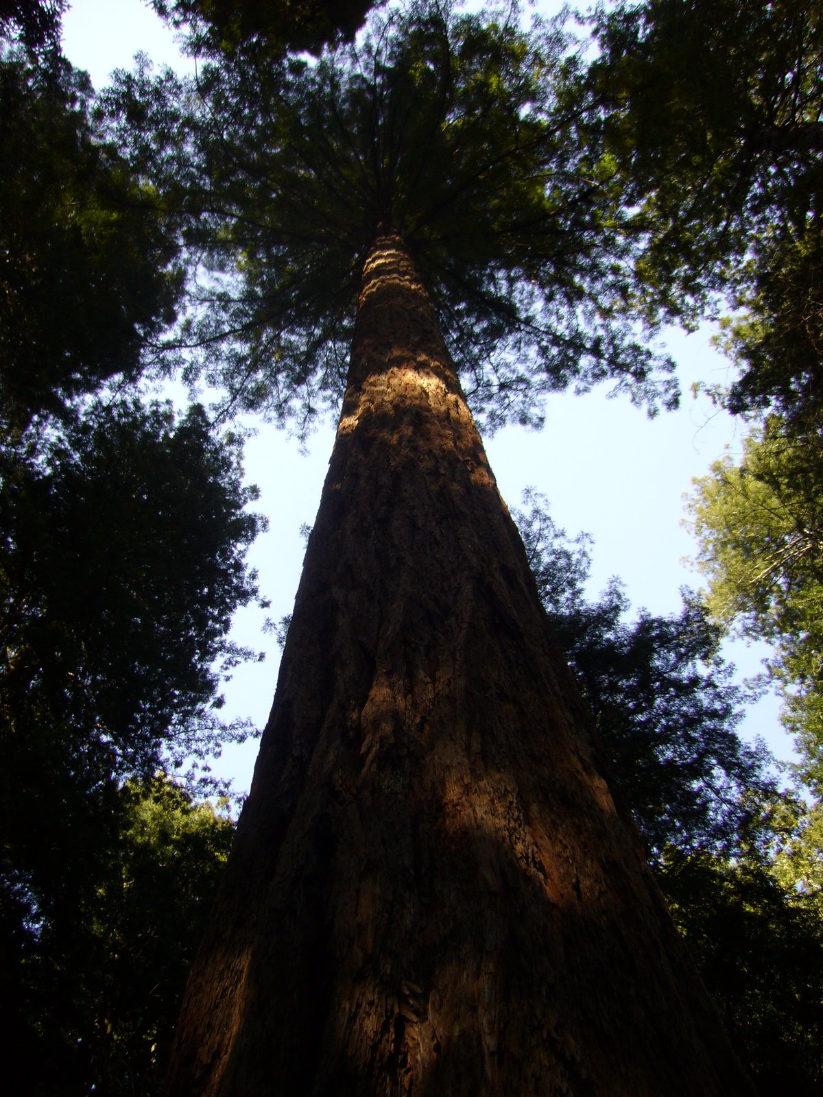
Jeffrey pine and white fir soften the stark, towering granite walls

p1020761_2

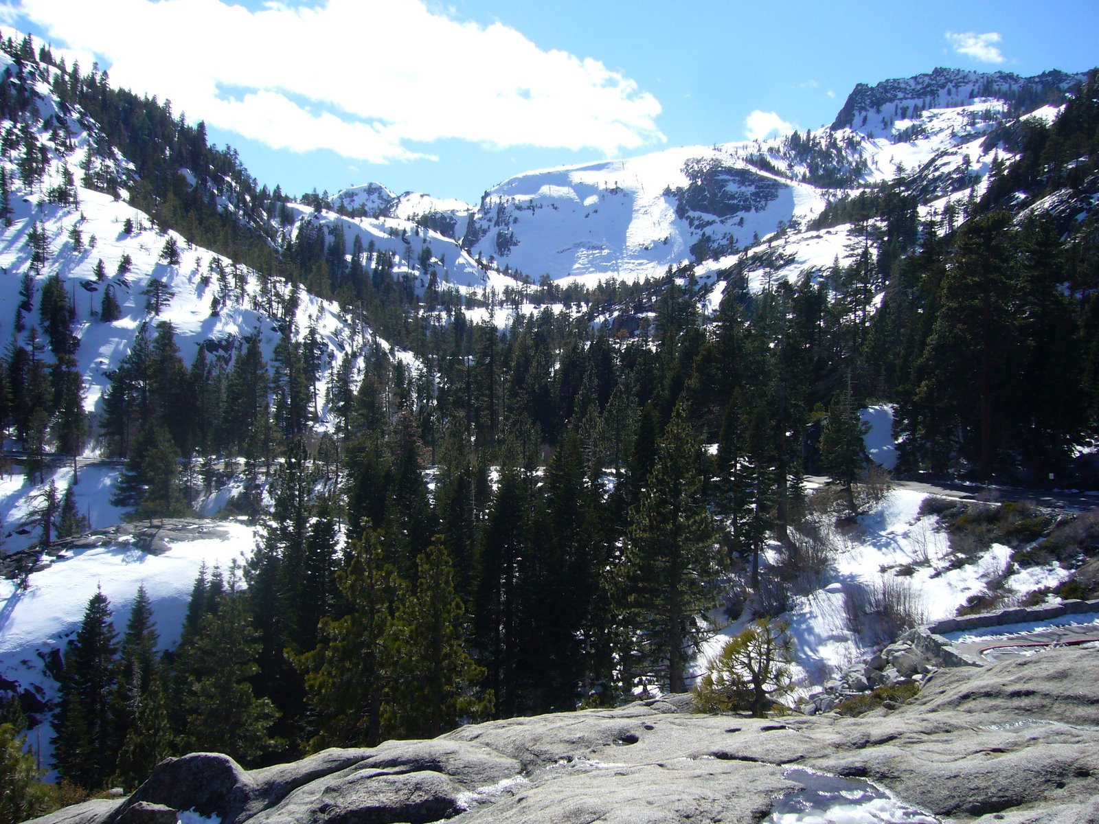
Evidence of glacial carvings can be seen in the American River valley below.

p1020763_2

A small waterfall flanked by Jeffrey pine and Sierra juniper previews what is still to come.

p1020765_2

Another view south into the American River valley from a little higher up.

p1020769_2

Horsetail Falls is gushing from the snowmelt.

p1020771_2

A distant view of Horsetail Falls.

p1020773_2

Looking down on the Cascade Vista and the American River valley.

p1020777_2

A distant view of Horsetail Falls from the Cascade Vista.

p1020780_2

Pyramid Creek sheets in a continuous cascade over the granite bedrock.

p1020782_3

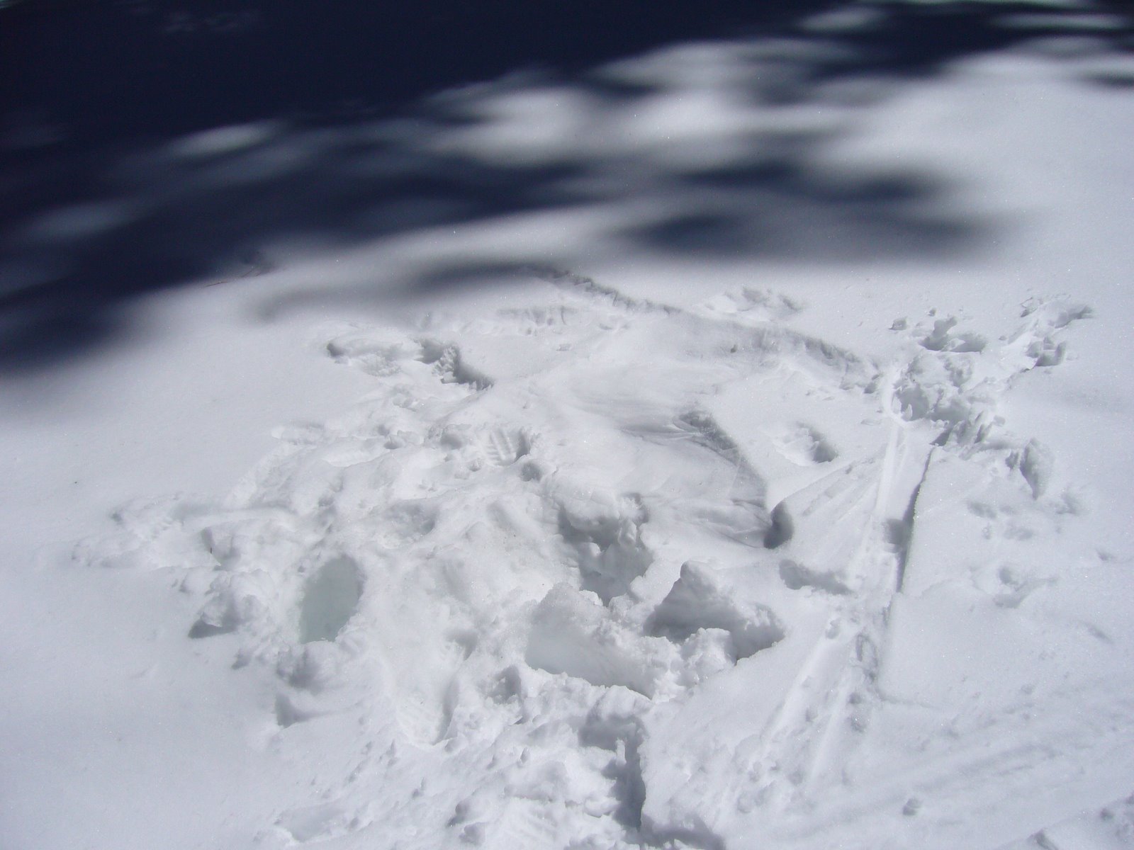
Deep snow was a continuous obstacle for myself, and for 4'-tall Madison.

Copyright © Ted C. MacRae 2009

Add to FacebookAdd to NewsvineAdd to DiggAdd to Del.icio.usAdd to StumbleuponAdd to RedditAdd to BlinklistAdd to Ma.gnoliaAdd to TechnoratiAdd to Furl

Emerald Bay State Park – Vikingsholm and Rubicon Trails

I had attempted to hike the Eagle Falls Trail two days ago, but deep snow stopped us just below the Upper Falls before reaching the lake. I had noticed, however, that the lower elevations on the west shore of Emerald Bay looked fairly free of snow, and a conversation the following morning with an extraordinarily helpful staff member at the USDA Forest Service’s Lake Tahoe Basin Management Unit headquarters in South Lake Tahoe confirmed that the entire Vikingsholm Trail in Emerald Bay State Park and much of the Rubicon Trail in Emerald Bay State Park and D. L. Bliss State Park immediately to the north should be passable. My objectives were two-fold – hiking and botanizing. I wanted to get in at least 6 miles, and up to 10 would be even better; and I also wanted to locate and identify as many of the woody plants known from the area as possible. I probed the incredibly helpful USDA representative about the subtleties of distinguishing ponderosa pine from the ubiquitous but very similar Jeffrey’s pine, where I might see magnificently mature specimens of sugar pine and the grotesquely beautiful Sierra juniper, how to recognize the moisture loving lodgepole pine, and the slim chance of seeing western white pine due to its preference for higher altitudes. I commented about how I looked forward to seeing stately red firs and wind-swept whitebark pine when I went skiing later in the week – maybe I would be fortunate enough to find western white pine amongst them. I purchased three books: Conifers of California by Ronald Lanner, Discovering Sierra Trees by Stephen Arno, Plants of the Tahoe Basin by Michael Graf and National Geographic’s Trails Illustrated Map™ for Lake Tahoe Basin (my souvenirs for the trip), thanked the wonderfully knowledgeable USDA representative for her help, and bolted up to Emerald Bay. On an extraordinarly warm and delightful mountain day in spring, I hiked down the Vikingsholm Trail to Vikingsholm Castle, stopping frequently to sample and photograph plants, then hiked the Rubicon Trail all the way to Emerald Point at the mouth of Emerald Bay. I hopped on rocks out into the point until I could not go any further and turned around to admire a view that few people have experienced by foot. I lost the trail along the way due to snow, but I did not get lost – I could not get lost with a lake on one side of me and a mountain on the other. Going beyond Emerald Point the snow got too deep – a few steps where I sunk up to my hip confirmed that further passage without snow shoes would be impossible. I bushwhacked back until I found the trail and chose alternate paths the rest of the way. By the time I returned to my car, I had hiked 7 miles in 5½ hours (yes, I’m pokey), encountered only a handful of people (all within a quarter mile of the parking lot) and taken 110 photographs. I share seven of them with you here:

East shore (lateral glacial morraine) of Emerald Bay from Vikingsholm Trail.  Heavenly Ski Resort and the southeast shore of Lake Tahoe can be seen in the distance.

East shore (lateral glacial morraine) of Emerald Bay from Vikingsholm Trail. Heavenly Ski Resort and the southeast shore of Lake Tahoe can be seen in the distance.

Mt. Tallac (L) and Maggie's Peaks (R) from Vikingsholm Trail

Mt. Tallac (L) and Maggie's Peaks (R) from Vikingsholm Trail

Fannette Island from Vikingsholm Castle

Fannette Island from Vikingsholm Castle

Emerald Point from the west shore of Emerald Bay

Emerald Point from the west shore of Emerald Bay

Emerald Bay and Maggie's Peaks (L) from Emerald Point

Emerald Bay and Maggie's Peaks (L) from Emerald Point

West shore of Emerald Bay from Emerald Point

West shore of Emerald Bay from Emerald Point

Zoom view of Emerald Bay from Emerald Point

Zoom view of Emerald Bay from Emerald Point

Copyright © Ted C. MacRae 2009

Add to FacebookAdd to NewsvineAdd to DiggAdd to Del.icio.usAdd to StumbleuponAdd to RedditAdd to BlinklistAdd to Ma.gnoliaAdd to TechnoratiAdd to Furl

Born of glaciers

Three months of camp life on Lake Tahoe would restore an Egyptian mummy to his pristine vigor, and give him an appetite like an alligator.–Mark Twain, Roughing It (1872)

p1020578_2 When Mark Twain first laid eyes upon Lake Tahoe in 1861, he thought it “must surely be the fairest picture the whole earth affords.” More than a century and a half later, that opinion is still shared by another Missouri boy, and though I would gladly welcome three months of camp life over one week at a ski resort, I nevertheless remain confident that my vigor will be fully restored by the time I return to work next Monday. The journey that began some days ago in the foothills of my beloved, ancient Ozark Highlands has today taken me to one of the youngest of landscapes to grace Lake Tahoe – Emerald Bay. I have written previously about Lake Tahoe (one year ago almost to the day) in a post that also featured photos of Emerald Bay and its only island, the iconic Fannette Island. p1020596_2 The Tahoe Basin itself is a relatively young landscape, forming within the last 5-10 million years as the basin floor dropped between two uplifted blocks. Volcanic flows in the valley on the north side of the present lake dammed the valley to form the lake, whose level has fluctuated drastically over time during the past 2 million years as Pleistocene glaciations have repeatedly damned the Truckee River that drains the lake into the lowlands of Nevada. At maximum, the level of the lake approached 7,000 feet in elevation – nearly 800 feet higher than today. p1020577_2 It was the last of these glacial events – near the end of the Pleistocene just 10,000 years ago – that gave birth to Emerald Bay. Unlike the “ice sheets” that spread out across much of the continent, the ice age here manifested itself as individual glaciers that formed at the highest elevations and carved out individual valleys as their crushing weight ground them inexorably downward. The elongated shape characteristic of such glacial valleys is seen not only in Emerald Bay, but in the adjacent Fallen Leaf Lake and Donner Lake in the north as well. John Muir alludes to this glacial birth in a description of Emerald Bay that he wrote in his private journal in 1888:

Emerald Bay is about two miles long. Its mouth is nearly closed by a terminal moraine; the sides are formed by lateral moraines. The left lateral is very striking, well formed, three or four hundred feet high where it joins the shoulder of the mountain, timbered with pine and spruce¹ sparsely on the grayish slopes.

¹ Actually firs, of the genus Abies.

Upper Eagle Falls from Eagle Lake - part of a ''glacial staircase'' above Emerald Bay

Upper Eagle Falls from Eagle Lake - part of a

Unfortunately, the very existence of Lake Tahoe is under threat. While the mountain building processes that created the Sierra Nevada have ceased for now, the erosive forces caused by weathering continue unabated. The Sierra Nevada range is being gradually worn down, and Lake Tahoe is filling with sediment at an average rate of about 1/10th of a millimeter per year. At this rate, Lake Tahoe will become a meadow in just over 3 million years.[/humor]

Lake Tahoe facts:

  • It is 22 miles long, 12 miles wide, and holds about 40 trillion gallons of water – enough to cover the entire state of California to a depth of 14.5 inches!
  • Maximum elevation of the lake surface is about 6,229 feet above sea level.
  • The lake is drained by the Truckee River, one of a few rivers that run inland to the desert rather than towards the ocean.
  • It is the third deepest lake in North America, with an average depth of 989 feet. However, the deepest point is about 1,645 feet.  It is the largest lake in North America above 600 feet elevation.
  • Surface temperatures can reach as high as 75°F in summer, but at depths below 600 feet the water remains a constant 40°F.
  • Lake Tahoe does not freeze over, although Emerald Bay has formed complete ice cover at least three times during the 20th Century and partial cover in more years.

More Lake Tahoe facts can be found at the U.S.D.A. Forest Service, Lake Tahoe Basin Management Unit FAQ site and at Tahoe Topics and FAQ’s, by David C. Antonucci (2004).

Copyright © Ted C. MacRae

Add to FacebookAdd to NewsvineAdd to DiggAdd to Del.icio.usAdd to StumbleuponAdd to RedditAdd to BlinklistAdd to Ma.gnoliaAdd to TechnoratiAdd to Furl

A journey through time

hole_in_the_mountain

East Humbolt Range, northeastern Nevada

During the past two days, my family and I made the long drive from St. Louis, Missouri to Lake Tahoe, California to enjoy a week of skiing (both alpine and cross-country), snow-shoeing, hiking (at lower elevations), and decompression.  At 1,990 miles, it’s not a drive for the pampered or easily bored (and for those with children, thank goodness for in-car DVD players). Yet, for those willing to explore the little seen wonders of a landscape that most people see only from 30,000 feet, driving cross-country can be a richly rewarding experience.  I have traveled through many parts of the U.S., but this was my first time experiencing the “northern route” between Missouri and California along I-80.  Along the way, I saw:

  • Massive flocks of snow geese roosting in wetlands along the Platte River Valley, rising up at morning’s light in swirling clouds and stringing across the sky in vast, intersecting “V”s as they begin another day on their journey northward.
  • Sandhill cranes in the Nebraska Sand Hills, dropping down from the sky like miniature parachutes as they congregated in fallow corn fields to feed amongst the stubble.
  • The vast, high, arid, lonely expanses of the Wyoming Basin, transitioning from mixed-grass prairie in the east to sagebrush steppe in the west.
  • The stunningly spectacular descent down the western escarpment of the Wasatch Range, where the eastern edge of the Great Basin laps against the western edge of the Rocky Mountains.  (Nightfall unfortunately deprived me of my chance to see the vast Great Salt Lake and the even more expansive stretches of its associated salt flats.)
  • The magnificent Great Basin landscape and its alternating basin and range theme – its broad basins of salt lakes, marshes and mud flats interrupted at regular intervals by craggy, north to south mountain ranges formed as a result of strike-slip faulting during the past 30-50 million years as the thin Basin crust continues to crack and stretch even thinner.
  • The dramatic eastern face of the Sierra Nevada Range, its snow-capped peaks rising massively as a single granite block at the western edge of the Great Basin, and the equally dramatic, tortuous climb up to Spooner Pass at 7,200′ elevation before the 1,000′ drop down into the majestic Lake Tahoe Basin.

Driving across such a vast expanse of North America, especially in the west with its endless vistas and majestic landscapes, invites contemplation about earth and time.  Starting out in the foothills of my beloved Ozark Highlands – born before life itself and weathered for a billion and a half years, driving through the upstart Rocky Mountains – mere babies at only 50-100 million years of age, and finally arriving at the truly young Lake Tahoe – whose mere few million years of age make it a mere infant in geological time, I realized that the vastness of these landscapes, and of the countless tectonic, erosional and sedimentary episodes that shaped them, is surpassed only by the vastness of the time it took to create them.  For those willing to make the investment, driving through these landscapes is more than a trip across the country – it is a journey through time.

Copyright © Ted C. MacRae 2009

Add to FacebookAdd to NewsvineAdd to DiggAdd to Del.icio.usAdd to StumbleuponAdd to RedditAdd to BlinklistAdd to Ma.gnoliaAdd to TechnoratiAdd to Furl

New species and a review of the genus Tragidion

ResearchBlogging.orgSpecies of Tragidion are among the larger and more attractive cerambycids in North America, making them popular among collectors. Their bright orange and black coloration clearly functions in mimicking spider wasps (family Pompilidae) in the genera Pepsis and Hemipepsis – the so-called “tarantula hawks.” Unfortunately, species of Tragidion have been difficult to identify due to a high degree of morphological similarity between species, wide range of variation across geographic areas within species, unusually high sexual dimorphism and dichromatism, and apparent potential for hybridization in areas of geographic overlap. This has confounded efforts to delimit species boundaries, resulting in a confusing assortment of names whose proper application has eluded even the most esteemed of North America’s cerambycid taxonomists. Recently, some much needed clarity was provided by Ian Swift and Ann M. Ray in the journal Zootaxa. Their taxonomic review of Tragidion – the first systematic treatment of the entire genus – recognizes seven species in North America and another four restricted to Mexico. Two species – T. agave from California and Baja California and T. deceptum from montane areas of the southwestern U.S. and northern Mexico (both pictured) – are described as new, and a third – T. densiventre from desert areas of the southwestern U.S. and northern Mexico – is raised from synonymy under T. auripenne. Four new synonymies are also proposed, and dorsal habitus photographs and a key to all species are provided. Life history information is limited for most species of Tragidion. One species – T. coquus – occurs broadly across the eastern and central U.S., where it breeds in a variety of dead hardwoods, especially oak. Several species occur in the southwestern U.S. and northern Mexico – some are found in xeric lowland desert habitats, where they breed in dead branches of Prosopis glandulosa and Acacia greggii (T. densiventre) or dead flower stalks of Yucca and Agave (T. agave and T. armatum), while a fourth (T. deceptum) is found in more montane habitats mining the heartwood of recently dead branches of Quercus. Adults of another species in California and Baja California, T. annulatum, are strongly attracted to brushfires and burning vegetation, and individuals have been observed landing on still-burning and smoldering shrubs, causing their legs and abdomens to melt to the surface of the branches. At several post-burn sites, the melted bodies of this species were common on the charred branches of their hosts, and females have been observed ovipositing on woody shrubs that have been burned. This species likely plays an important role in the decomposition of burned woody material in coastal areas of California. The remaining U.S. species – T. auripenne – is known from only a handful of specimens collected in xeric habitats in the Four Corners region of the southwestern U.S. It’s life history, as well as those of the four strictly Mexican species, remains essentially unknown.

Tragidion agaveTragidion agave Swift & Ray 2008, ♂ & ♀ – California & Baja California. Tragidion deceptumTragidion deceptum Swift & Ray 2008, ♂ & ♀ – southwestern U.S. and northern Mexico.

REFERENCE: Swift, I., Ray, A. M. (2008). A review of the genus Tragidion Audinet-Serville, 1834 (Coleoptera: Cerambycidae: Cerambycinae: Trachyderini) Zootaxa, 1892, 1-25

Trichinorhipis knulli

Just a little diddy on one of the more interesting species I’ve encountered over the years while I finish up a longer piece on the Loess Hills of Missouri. The specimen shown here is a male Trichinorhipis knulli. This quirky little species belongs to the equally quirky little tribe Xenorhipidini (family Buprestidae). Members of this tribe are among the few groups of Buprestidae in which evolution of the male antenna has diverged dramatically from the typical condition (i.e., serrate). In the Xenorhipidini, this condition may be considered very extended flabellate or even lamellate. As I mentioned, only males exhibit this antennal modification – females possess typical serrate antennae. The functional significance of this almost certainly involves detection of female sex pheromones. The surfaces of the flabellae in these species are covered with numerous presumably olfactory sensillae that are lacking on female antennae, and males of a related species (Xenorhipis brendeli) have been observed attracted in large numbers to caged live females. This antennal condition appears to have arisen independently in three other groups of Buprestidae as well, but Xenorhipidini is the only non-monotypic tribe in which males of all member species possess the condition.

Trichinorhipis knulli is restricted to southern California and has been encountered most often in the vicinity of Mountain Springs in Imperial County (just north of the Mexican border), where it breeds in dead branches of jojoba, Simmondsia chinensis. Very few individuals have actually been observed in the field – most existing specimens have been reared from caged, infested branches (as is the case with this specimen, which emerged August 1994 from a dead branch I collected in October 1992 – patience prevails!). At only 3.6 mm in length, it is one of the smallest members of the family, but I think you’ll agree that it is just as impressive under the microscope as any of the larger members of the family. The genus is monotypic (although I hear rumor of an undescribed species from west Texas) and has been placed in its own subtribe (Trichinorphidina) within the Xenorhipidini due to unique characters that distinguish it from the other included genera (Hesperorhipis and Xenorhipis). These include its entire (not abbreviated) elytra and broadly rounded pronotum lacking lateral margins. In Hesperorhipis and Xenorhipis the elytra are abbreviated, and the pronotum is quadrate with distinct lateral margins. The organization of the antennal sensillae also differs between Trichinorhipis and these other genera.

The tribe Xenorhipidini is currently being revised by my colleague and friend, Dr. Charles Bellamy, California Department of Food and Agriculture, Sacramento.

Muir Woods National Monument

This is the best tree-lovers monument that could possibly be found in all the forests of the world. – John Muir

Coastal redwood (Sequoia sempervirens) is the tallest type of tree in the world, with maximum recorded heights approaching 380 feet. This majestic conifer grows only along the Pacific Coast in a narrow strip from Monterey to Oregon. Most of the estimated 2 million acres of original redwood forest are now gone — victims of the saw! One of the small groves that managed to escape this fate due to its relative inaccessibility grows along Redwood Creek and adjacent slopes in what is now Muir Woods National Monument. At heights approaching 260 feet, the redwoods growing here are not the tallest to be found; however, their proximity to San Francisco (just 15 miles from the Golden Gate Bridge) makes them the most heavily viewed examples of this ancient tree. Lynne and I visited Muir Woods a few times in the 90’s after moving to Sacramento — today (3/20) was our first visit since then, and the first ever for Mollie and Madison. In addition to getting to see these marvelous trees once again, we were also treated to a spectacular display of spring wildflowers.

We began our hike on the main paved trail. This is where most visitors confine themselves during a visit to this place, so the picture here documents a rare sight — no people! I apologize for its lack of focus, a consequence of the limitations of my little point-and-shoot camera in the limited amount of light that makes it through these towering trees during late afternoon.

Standing beneath one of these trees and looking up is a lesson in insignificance — the feeling one gets looking straight up the trunk of one of these giants cannot be adequately captured on film (er… microchip).

We quickly tired of the crowds and decided to hike up the Ocean View Trail, which climbs quite steeply up the east side of the valley. This marvelous trail was nearly devoid of people, and we found ourselves winding through thick, dark, cool forest with numerous side ravines. The lower elevations of the trail were dominated by redwood trees and a spectacular array of spring wildflowers. Among the most common was California toothwort (Cardamine  californica [=Dentaria californica]), a member of the mustard family (Brassicaceae). I noticed that the leaves at the base of the plant were broad and oval, while those arising from the flower stalk were slender and lanceolate, often divided into 3 leaflets.

Wake robins (genus Trillium), belonging to the lily family (Liliaceae, sometimes separated into the lily-of-the-valley family, Convallariaceae), are among my favorite wildflowers. We soon noticed Western wake robin (Trillium ovatum) growing commonly in shaded areas along the trail. We were also seeing some purple-flowered wake robins — at first I thought they were a different species, but it soon became apparent that these were older Western wake robin flowers, which change color from white to purple as they age.

A little further up the trail we began encountering small patches of Mountain iris (Iris douglasiana, family Iridaceae). Flower color for this native species ranges from cream-white to lavender, but all of the flowers we saw were of the white variety.

We saw this fat Solomon’s seal (Maianthemum racemosum ssp. amplexicaule [=Smilacina racemosa var. amplexicaulis]) growing in one of the cool, moist, side ravines. This is another member of the Liliaceae (sometimes separated into the Convallariaceae). The large, oval leaves clasping around the distinct, unbranched stem were almost as attractive as the flowers, which apparently give rise to bright scarlet berries in the summer.

In the middle elevations the redwood forest transitioned to drier oak woodland containing a mixture of Douglas-fir (Pseudotsuga menziesii), Pacific madrone (Arbutus menziesii), bigleaf maple (Acer macrophyllum), and tan oak (Lithocarpus densiflorus). Some of the Douglas-firs were enormous.


Indian warrior (Pedicularis densiflora) is a member of the figwort family (Scrophulariaceae, sometimes separated into the Orobanchaceae). This plant, with its striking bright red flowers and finely divided, fern-like leaves, is a facultative parasite on the roots of other plants. Apparently, the genus name refers to an old superstition that sheep could become infested with lice if they ate this plant.


The juncture of the Ocean View Trail with the Lost Trail was closed, so we backtracked down the 1+ miles back to the main paved trail. By now it was fairly late in the afternoon, and the crowds had thinned considerably. Having gotten lots of good views of the giant trees, we began turning our attention downwards to the smaller understory flora. Ferns, of course, are a dominant component of this understory, especially along Redwood Creek. This large specimen may represent Western sword fern (Polystichum munitum) (family Dryopteridaceae), which can apparently be distinguished by small hilt-like projections from the base of the pinnae (leaflets), but I couldn’t get close enough to see for sure.


Abundant on the ground in the valley was redwood sorrell (Oxalis oregana), a member of the family Oxalidaceae. In places this plant covered the ground in thick carpets.


Among the more interesting plants we saw in the valley was California fetid adder’s tongue (Scoliopus bigelovii), yet another member of the Liliaceae or Convallariaceae. I wasn’t sure what this plant was at first, despite its highly distinctive, glossy, mottled foliage. We were too late to see the blooms, which apparently have a fetid odor to attract flies for pollination, but did find the maturing pods on their slender, drooping stems.


Close to the creek’s edge we saw this colony of horsetails (Equisetum sp.), primitive plants in the family Equisetaceae. Members of this group belong to one of the most ancient lineages of vascular plants, dating back to the Devonian period (416-359 million years ago). Their Paleozoic ancestors (Calamitaceae and Archaeocalamitaceae) were giants, reaching heights of 50 ft or more, and were major components of the Carboniferous swamplands. Along with lycopod trees (Lepidodendrales), they were important contributors to coal formation and, like the lycopods, became extinct by the mid-Permian (~270 million years ago). The genus Equisetum represents the only surviving descendants of this lineage. Unlike their extinct progenitors, these small, herbaceous plants rarely exceed 4 ft in height; however, they share many of the same characters such as articulate stems with microphylls arranged in whorls. Recent phylogenetic studies, using both molecular and morphological characters, suggest that horsetails, together with ferns, form a clade representing one of the three major lineages of vascular plants (Pryer et al. 2001).


Nearby we saw a patch of Giant wake robin (Trillium chloropetalum) in flower. These were taller than the California wake robins we saw on the slopes of the Ocean View Trail but similarly characterized by a whorl of 3 leaves and flowers composed of 3 erect petals. Mature flowers darken to a deep red purple, so it seems these plants had just begun flowering. Muir Woods appears to be a good place for observing a diversity of Convallariaceae!


Also along Redwood Creek we found this bigleaf maple (Acer macrophyllum) in full bloom. As its specific epithet suggests, this maple has the largest leaves of any member of the genus — in this example the newly-expanded leaves were distinctly purplish. The picture below shows the greenish-yellow flowers (petals inconspicuous) produced on long, pendulous racemes.


Interpretive signs along the paved main trail pointed out a redwood “family group,” formed by sprouts growing from the base of a larger tree. Eventually, the central “mother” tree died and decayed away, leaving a ring of offspring that mature into an enormous, characteristic circle of trees. This apparently also happens with other types of trees, though on a smaller scale, as demonstrated in this picture of an oak (Quercus sp.) family group.


As the day drew to a close we found ourselves back in the parking lot, where this California icon, a clump of Coast live oak (Quercus agrifolia), was spreading its wide, majestic crown from multiple, twisted trunks and gnarled branches.


Much too soon, it was time to leave this beautiful valley, but before heading back to Sacramento we stopped to take one last look down towards the valley and out to the Pacific Ocean from the Panoramic Highway.

Lake Tahoe, California

…at last the Lake burst upon us — a noble sheet of blue water lifted six thousand three hundred feet above the level of the sea, and walled in by a rim of snow-clad mountain peaks that towered aloft full three thousand feet higher still! It was a vast oval, and one would have to use up eighty or a hundred good miles in traveling around it. As it lay there with the shadows of the mountains brilliantly photographed upon its still surface I thought it must surely be the fairest picture the whole earth affords. – Mark Twain, Roughing It (1872)


Mark Twain may not have liked the name “Lake Tahoe” – preferring its then-official, patronimic designation as “Lake Bigler.” However, he was clearly overwhelmed by its beauty, and surely no person who has ever seen this place can find fault with the words he so eloquently penned almost a century and a half ago. The view above of Emerald Bay, on the south side of the lake, may not be where Twain first viewed Lake Tahoe, but for me it is the most iconic place from which to view it. I first fell in love with Lake Tahoe almost 18 years ago, when my then fiancée and I first moved to Sacramento. We married up there, and for the 5 years we lived in California we spent many a weekend enjoying Tahoe’s 4-season charm. It has been 12 years since we moved back to St. Louis, and I hadn’t been back — until this past weekend. The reasons for the delay are many, but returning to this place reminded me why I consider it the most beautiful place in the world. I shall not let so long a time pass before my next visit.

Lake Tahoe is a relatively young lake, forming within the last several million years (in contrast, the block of granite that was to become the Sierra Nevada mountains – and in which Lake Tahoe lies – began forming during the Paleozoic Era and was then exposed by erosion beginning about 130 million years ago). The basin in which the lake lies was formed by fault-induced block slippage between two uplifted blocks, with the lake itself forming after magma upwellings dammed the northern part of the basin. Glacial action in more recent years (2 million to 20,000 years ago) caused additional damming, causing drastic fluctuations in the lake level — maximum levels reached nearly 800 feet higher than present. The most recent glaciations (~10,000 years ago) carved out Donner Lake (just east of Lake Tahoe), Emerald Bay (above), and nearby Fallen Leaf Lake (below — the frozen lake surface can just be seen above the trees in the foreground).


Emerald Bay is actually part of a glacial “staircase” featuring intermittent flat stretches containing lakes and meadows before ultimately ending at Emerald Bay. Eagle Lake lies immediately above Emerald Bay on one of these “steps,” and the 1-mile trail to it is one of the most popular hikes in the area — below is a view towards Eagle Lake from Emerald Bay:


On the day we arrived (Sat 3/15), a late winter storm was dumping new snow on the surrounding mountains, as seen in this view across the south end of the lake towards the city of South Lake Tahoe. Heavenly Ski Resort was shrouded from view on this day, but the fresh powder being dumped there would provide for some delightful spring skiing over the next few days.


In the meantime, there would be plenty of activities to keep ourselves occupied. With the amount of snow on the ground, one might think there would be little opportunity for botanizing. However, I favor the woody flora, and I was excited about the chance to begin reacquainting myself with some of the western conifers for a change. Of these, one of my favorites is incense-cedar (Calocedrus decurrens) — mature trees develop thick, deeply furrowed, brick red bark that stands out in beautiful contrast from the other trees. Even dead trees maintain a rustic and majestic beauty, and this large dead snag is as stately as any I’ve seen:


On Monday we rented snowshoes and hiked the cross-country ski trails at Camp Richardson. None of us had ever snowshoed before, but the girls quickly got the hang of it (note the live incense-cedar in the background):


We encountered a few cross-country skiers during our hike, but for the most part we spent the day in solitude. Shortly after beginning our hike, however, we came upon this impression in the snow. At first we thought someone had attempted to make a “snow angel,” but after studying it more carefully we realized it was made by a cross-country skier who had fallen and then struggled to get back up:


At this altitude, conifers dominate the flora. I was a little rusty on my knowledge of western U.S. plants, but I think I have things figured out (please let me know if you see any needed corrections to my identifications). The aforementioned incense-cedar was a conspicuous component of this lake-level forest, and its foliage – arranged in flattened, elongated, rumpled sprays – makes this tree easily identifiable amongst the other coniferous genera with which it grows:


Huge pine trees also dominanted the forest in this area. At first I thought they were ponderosa pines (Pinus ponderosa) due to their large size, irregular crown, and large plate-like patterns on the trunk caused by deep cross-checked fissuring of the bark. Eventually, however, I decided they must instead be Jeffrey pine (Pinus jeffreyi), a closely related species (that was once considered a variety of ponderosa pine), since the bark was more orange than yellow.


A closeup of the needles, which are in bundles of three and measure around 6-8 inches in length:


Another dominant coniferous component of this forest, also reaching massive size, was white fir (Abies concolor). The first photo below shows a large, mature tree in the distance, while the second shows a closeup of the foliage. At first I thought this might be Douglas-fir (Pseudotsuga menziesii), as the needles appeared to be irregularly 2-ranked; however, I asked Prof. Ronald Lanner to take a look, and he confirmed it is white fir. He said Douglas-fir needles are shorter, thinner, darker green, and have a skinny stalk, while fir needles have a fat round base and are wider and flatter. The latter also have a citrusy smell when crushed, which he describes as one of the best smells in the woods! Too bad I did not try it.


This decaying stump also represents white fir based on the scaly gray bark. I suspect the outer layers of the lower portion of the trunk (core still standing) were ripped off over time by animals looking for grubs and insects as decay progressed, eventually weakening it to the point that the upper portion (laying on the ground) finally broke off and fell:


As we hiked, I realized what an important part fire plays in the ecology of these forests. During the drive up from Sacramento, we passed several areas along Hwy 50 that had suffered severe damage due to the wildfires that swept through Lake Tahoe recently. One such area was even seen in the far eastern slopes of Heavenly Ski Resort itself. The forests around Camp Richardson had largely escaped these fires, and I wondered if fire management had contributed to this. Along the trail, evidence of fire was common on the trunks of trees, but few trees – even small ones – had been killed. I presumed the charring was evidence of fires that had been intentionally set and managed by the Forest Service with the objective of preventing fuel accumulation that could lead to the larger conflagrations that caused so much damage in other parts of the basin. These small incense-cedars trunks show obvious fire charring but otherwise looked healthy:


In a few areas it appears even these “cool” fires burned a little hot, killing some of the smaller trees but still avoiding the “torched-earth” damage seen in areas affected by uncontrolled burns:


I’m not much of a birder, but I do love woodpeckers. I got a glimpse of one during our hike, but I didn’t see it well enough to identify it. We did find this woodpecker hole in the trunk of a large, dead Jeffrey pine — a feather can even be seen clinging to the upper rim of the hole. The Lake Tahoe basin is home to several species of woodpeckers — whether this hole belongs to the black-backed woodpecker (Picoides arcticus), white-headed woodpecker (P. albolarvatus), or (more likely) hairy woodpecker (P. villosus) I can’t say for sure:


At the beginning of our hike, signs warning of bears and pleading not to feed them caught the girls attention. I told them it was winter and that they would be hibernating, but I wondered if at this late stage they might actually be starting to become active. It wasn’t long before we encountered these unmistakably bear tracks, made fresh in the new-fallen snow, and the more we looked the more abundant the tracks were to be found. I secretly (and the girls outwardly!) hoped we would see a live bear, but I don’t think the girls would have handled such an encounter very calmly:


I had intended to photograph some of the conifers seen at higher elevations while skiing at Heavenly Ski Resort, but I decided not to bring my camera. Pity, as I not only saw nearly pure stands of what I presume to be red fir (Abies magnifica), but also beautifully twisted and wind-gnarled pines at the highest elevations (+10,000 ft) that probably represent whitebark pine (Pinus albicaulis), judging by their highly forked trunks and upswept limbs. These magically grotesque trees were made even more beautiful by the previous day’s storms, which had deposited thick cakes of ice on their windward sides.

We coudn’t leave Lake Tahoe without one final visit to Emerald Bay. Below is a close up photograph of Fannette Island, the only island to be found in all of Lake Tahoe, and its famed “Tea House”:


We concluded our visit to Lake Tahoe by driving up Hwy 89 to Tahoe City for dinner at the Bridgetender Cafe before heading back to Sacramento. Next up — Muir Woods!