The Courtois Section is the northern terminus of the Ozark Trail (OT). Despite its proximity to the St. Louis metro area, it feels just as remote and wild as the more southern sections. Rich and I played hooky from work on Friday and made our first visit to this stretch of the Ozark Trail. At 40 miles in length, we’ll need to break it up into at least three parts, so for our first attempt we hiked the lower portion from Hazel Creek (where the Trace Creek section begins) north to the Hwy 8 trailhead. Apparently this portion of the OT is very popular with mountain bikers and equestrians; however, we didn’t encounter a single person all day.
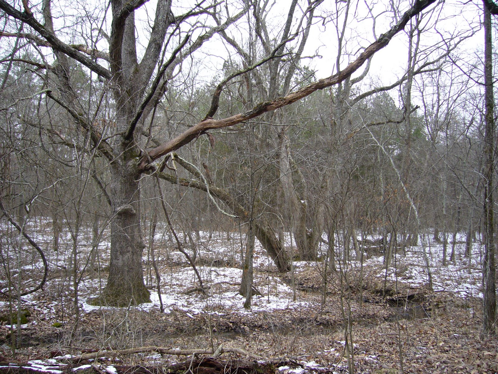
I expected the terrain to be rather mild at this northern end of the OT, but the first few miles were quite up and down. There was still some snow on the ground from a big storm a few days earlier – mild temps and sunny skies since then had caused a lot of melt. As a result, south facing slopes were completely devoid of snow cover, while north facing slopes still had and inch or two of snow, creating “split” scenes such as this:

Right away we noticed a lot of fresh woodpecker damage on oak trees. This is likely the result of infestations by the red oak borer (Enaphalodes rufulus), a cerambycid beetle that preferentially attacks red and black oaks suffering from drought or other environmentally-induced stress. The larvae of these beetles mine beneath the bark on the trunks of these trees before tunneling into the sapwood to pass the winter. Overwintering larvae are tasty morsels for woodpeckers, who hammer into the trunks with their beaks and extract the larvae with their barbed tongues. Interestingly, conventional wisdom has it that the tongue “stabs” the larva, and the barbs aid in pulling the larva out of its gallery. However, recent experiments with a West Indian species suggest this is not the case. Rather, the larva “sticks” to saliva on the tongue, and the barbs help to grab the larva as the tongue is wrapped around it. This picture shows a small black oak (Quercus velutinus) tree with fresh damage, probably from a pileated woodpecker (Dryocopus pileatus) judging by the size, going after one of these larvae.

A few miles into the trail, we came upon some curious “pits” covering one hillside. We speculated what they might be – sinks was an early thought, but I didn’t think that was so because the ground was mounded around the edge like they had been intentionally dug. Rich then remembered reading something about miners digging such pits in past years looking for minerals – we decided that must be what they were, and this was later confirmed in our Ozark Trail guidebook. Certain hillsides were literally covered with these pits, spaced ~10-15 feet apart.
After passing through Snapps Branch (where we noticed a small calcareous wet meadow, or fen – thankfully fenced), the trail leveled out for awhile before descending down to Boiling Springs Hollow where we stopped for lunch. Many of the larger valleys along the OT show some evidence of prior habitation – either by remains of old structures or by the stage of succession exhibited by the bottomland forest. Right at Boiling Springs, I noticed this large, old oak tree along with several large sugar maples (Acer saccharum) surrounded by younger forest – I suspect these “founder trees” were planted at some point when people lived near the spring (or at least spared from “the saw”) and remain as the only evidence of the people who lived here in the past.
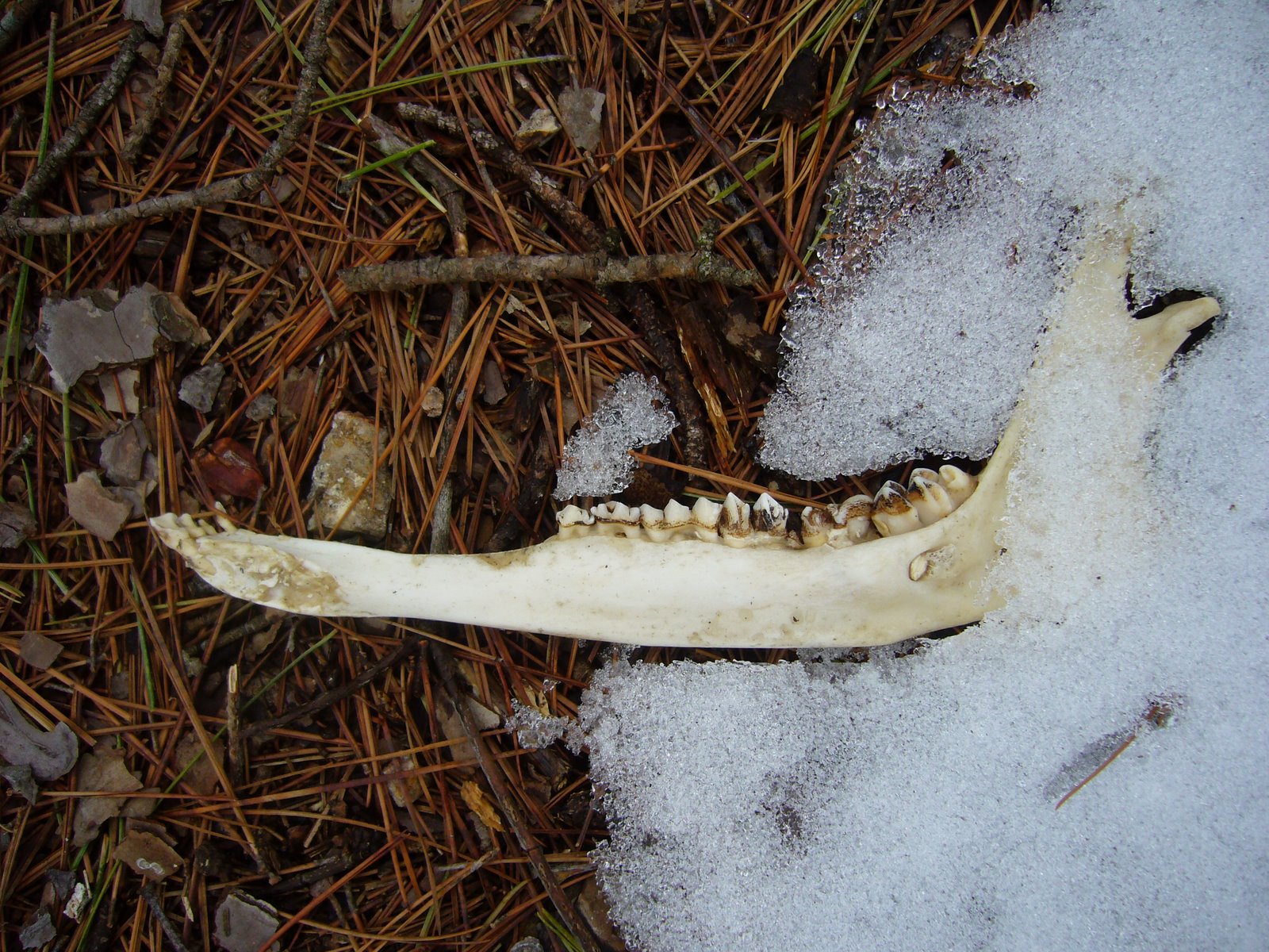
I love bones and pick them up whenever I get the chance. After leaving Boiling Springs I noticed this half mandible of a white tailed deer (Odocoileus virginianus) laying on the trail, still partially embedded in the snow. It was remarkably clean and complete, containing all of its dentition and with no remaining tissue except for a small piece attached to the nerve fossa. It’s completeness begged the question – where was the other half? We looked around and couldn’t find it. We then wondered if it had been dragged there by a scavenger, although we thought that if that was the case it should show signs of gnawing or at least have lost some of its dentition. At any rate, I have a white tailed deer cranium in my collection but not a mandible, so this will be a welcome addition.
Eventually we entered Machell Hollow, where we followed a beautiful stretch through the upper reaches of the valley. In this area we noticed a large number of dead white oaks (Quercus alba) that were all about the same size (~4-8″ dbh) and in about the same stage of decay, as if they had all died about the same time (maybe 4-5 years ago). There were still plenty of larger living trees, and I began to suspect that a fire had moved through this area and began looking for the evidence. Soon we found several larger trees showing some blackening around the base of the trunk that seemed to confirm this thought. We had a lot of fun “pushing over” some of these trees, with one in particular probably representing our champion pushover to this point. I didn’t think it was gonna go, but Rich chipped in, and against our formidable combined weight the tree gave way and came down with a crash. I noticed evidence of tunneling by wood boring beetles (probably a species of Buprestidae) inside the trunk of this tree where it cracked upon falling and lamented that I could not take a piece with me for rearing. All of the dead white oaks had this one type of shelf fungus growing from their trunks, which were particularly numerous on this already fallen tree:

Climbing up (briefly) out of Machell Hollow, we saw this cut shortleaf pine (Pinus echinata) laying by the side of the trail. Interestingly, the accumulated ice on the cut end of the trunk was not the result of water running off the trunk, but through the trunk, apparently through insect galleries and perhaps even the vascular bundles of the wood itself. The slow melt and freeze resulted in these interesting little ice columns joining the trunk to the moss-covered ground below.

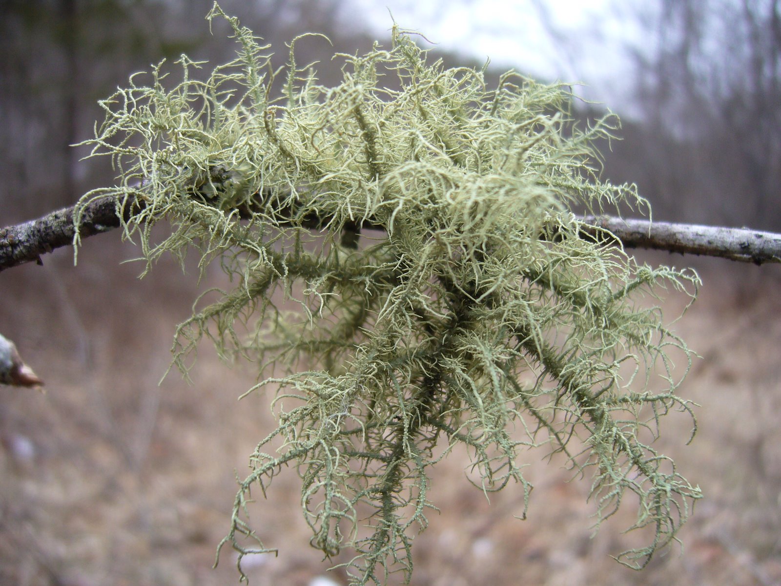
Back down into the lower reaches of Machell Hollow, evidence of prior settlement was obvious, as the bottomland forest in this area was replaced by young successional forest comprised primarily of chokecherry (Prunus virginiana), honey locust (Gleditsia triacanthos), and brambles (Rubus sp.). We saw this lone little fruticose lichen growing on a small honey locust. Apparently, of the three main groups of lichens, fruticose lichens are the most sensitive to environmental disturbance. Perhaps the existence of this one colony suggests that the health of this bottomland forest is returning as succession proceeds along the path to maturity.
Here’s a picture of Rich taking his own picture of the lichen. I don’t know why he didn’t just wait and steal mine once it got posted 😉

Much more abundant on the honey locust trees were these foliose lichens. Lichens in this group are probably the most commonly noticed lichens in the Missouri Ozarks (although the less conspicuous crustose lichens may actually be more diverse). If you click on the photo to see the full-sized version, you can see long, black “hairs” around the margin of each “leaf” – if anyone knows the identity of this or any of the other lichens pictured on this site please let me know.

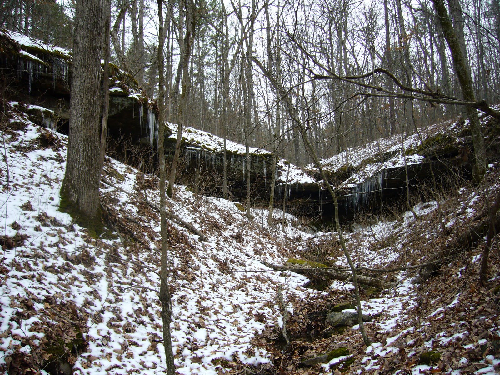
While ascending out of Machell Hollow, we noticed this small canyon about a hundred yards off to the left and decided to go investigate. Along the way we noticed the small creek coming from it was actually a ‘losing creek’ – which means that the water flows into the ground at certain points and is ‘lost.’ This is another feature of the limestone/dolomite-based Karst geology so common here in southern Missouri that results in its abundance of caves and springs. When we got to the canyon we saw it was comprised of a layer of sandstone. This must be a rare western exposure of the LaMotte sandstones that are more common just to the east in Ste. Genevieve County (see earlier posts on Hawn State Park and Pickle Springs Natural Area). This sandstone layer overlying dolomite has created an interesting geological feature, where a losing creek originates from a box canyon. Ice stalactites were dripping from the north facing slope of the canyon walls.
Back down into another hollow leading to Lost Creek we saw more dead white oaks with shelf fungi growing from the trunks. This one was interesting in that the shelf fungi were themselves supporting the growth of algae on their surface – an exquisite example of the interconnectedness of life.

We had seen a flock of wild turkeys (Meleagris gallopavo) moving through the forest earlier in our hike. We were too clumsily noisy to get close enough for more than a cursory look at them as they trotted off on high alert, but evidence of their activity was obvious as we saw their fresh “scratchings” over a wide swath through the forest as they searched for acorns to eat. Tracks were abundant in the snow around the area also, but I couldn’t get a good picture of them. Later, as we neared Lost Creek, I saw more tracks in the mud, so I was able to get a good picture of one. It looked fairly fresh (well defined, with nail holes evident):

Lost Creek represented the end of our hike, but it proved to be a more than insigificant final hurdle, as the water level was quite high due to all the recent snow melt. There was no choice, we would have to get wet. Rich is smarter than I and had thought to bring along some flip flops, so he took off his boots and socks, rolled up his pants, and forded the creek. I let him go first to see how deep the water was – it reached above his knees and got is rolled up pants wet. I decided to get my boots wet – I didn’t want to walk on those rocks barefoot, which would slow me down far more than I wanted in that cold water. I could handle wet boots for the final quarter mile in exchange for the comfort and speed they would provide on the rocks. Rich may be smarter, but I took a better line and didn’t even get my pants wet, so for me it was only a matter of changing into my comfy shoes back at the car, with no need for a change of clothes (which I also wasn’t smart enough to bring, either). We completed the hike in 7 hours – yes, we’re lollygaggers, constantly distracted by little things that most people either don’t see or don’t care about. It was a wonderful hike on another beautiful day, and we ended it with another traditional post-hike visit to the nearest pizza parlor before the short drive back to St. Louis.

Sounds like a great day. Thanks for taking your readers along for the ride.
That camera of yours continues to amaze me. Those closeups of the lichens very sharp.
It was another good day for a hike. We are now at approximately 215 miles of the Ozark Trail.